Posts

Busy week in the tropics
Image
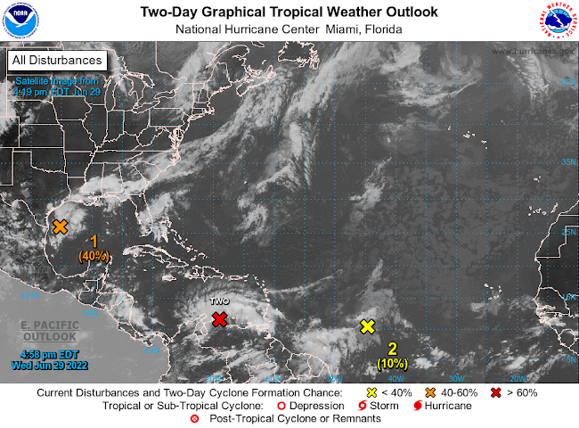
Active Atlantic Basin by Aidan Cera  The National Hurricane center is currently monitoring several disturbances out in the Atlantic this afternoon and have been for the last few days. The area with the most interest as of late has been Potential Tropical Cyclone 02L. Invest 95L is also churning in the Gulf of Mexico and has a 40% chance of developing in the next 2-5 days respectively. There is also a tropical wave located in the central Atlantic that may try to get going in the coming days but odds of this are only slight at this time.  Potential Tropical Cyclone 02L PTC 02L continues to struggle this evening under the influence of easterly shear and strong surface trade winds. Convection has also waned the last few hours as we approach the diurnal minimum. However, a surface circulation is evident on satellite imagery and based on surface observations out of Venezuela, therefore this is likely a tropical storm, but the NHC will likely not classify it as such until we see more...
Atlantic waking up?

Image
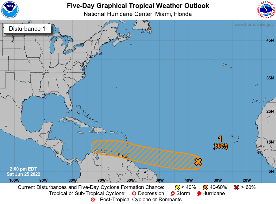
 Tropical Update 06/25/2022 Invest 94L by Aidan Cera The National Hurricane Center is currently monitoring Invest 94L, a tropical disturbance in the central Atlantic. This tropical wave has been tracked for several days now, and model consensus is that a tropical cyclone will likely come out of this wave at some point or another. When and where are heavily dependent on small scale and convective factors in the short term. There is a 30% chance of this wave developing a tropical cyclone in the next 2 days and a 60% in the next 5 days.  Currently, there is no convection associated with 94L and the disturbance is in bad shape. Dry, stable air and possibly cooler sea surface temperatures are putting a lid on thunderstorm development. Ironically though, a weak low level center is evident on satellite indicating that all this system needs is some consistent thunderstorm activity to be classified as a tropical cyclone.  One benefit of this convective demise is that it could...

SE Wisconsin 06/14/22 Weather

Image
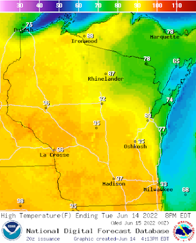
Wednesday SE Wisconsin Weather Excessive Heat Wednesday, with severe storms arriving Wednesday evening by Aidan Cera   The Heat Today has been extremely hot and humid across most of southeastern Wisconsin with lakeshore areas from Port Washington to north of Sheboygan being the exception due to a lake breeze out of the southeast.  A heat advisory is currently in affect for all of southeastern Wisconsin until 8pm on Wednesday, due to heat indexes peaking near 100F. Sufficient to say the miserable heat is expected to stick around going through tomorrow as southerly flow from the Gulf of Mexico advects moisture and heat northward. Even the lake shore communities will likely be in the 80s tomorrow to low 90s assuming the lake breeze does not kick in as it did today. Highs across most of southeast Wisconsin will be in the low to mid 90s, with heat index values near or possibly exceeding 100F. Dew points will remain in the low to mid 70s as well, so it will feel quite soup...

Volatile Day in Minnesota

Image
A volatile day ahead Severe storms expected across Minnesota for today Today is going to be a volatile day for most of Minnesota. Environmental conditions are conducive for a major severe weather outbreak this afternoon and evening. All modes of severe weather are expected this afternoon into this evening.  The Storm Prediction center has issues a moderate risk of severe weather for central Minnesota. Below are the probabilities of each hazardous type of weather associated with today's storms.  Above are the tornado probabilities. A 15% hatched risk of tornado is in place across much of central Minnesota. This means that not only are tornadoes a possibility, but large, long track tornadoes are expected as well.  Above are the probabilities for hail. There isa 30% hatched risk for a decent chunk of Minnesota. Hail damage will be possible to roofs, vehicles, people, animals as hail stones could be 2+ inches in diameter.  Above are the probabilities of se...

This weekend and Memorial Day for Minnesota

Image
Saturday, Sunday and Memorial Day Minnesota forecast  Severe thunderstorms expected across Minnesota this weekend An enhanced risk of severe thunderstorms is currently in place for much of Minnesota for Sunday and Memorial Day. A powerful negatively tilted trough is currently digging into the western portion of the United States and will provide a favorable environment for severe thunderstorm development.  Rest of Saturday The first round of precipitation has exited Minnesota for the most part with a few lingering showers in far southeast Minnesota. The remainder of the day looks to be dry thanks to a thermal ridge propagating eastward behind this mornings shortwave. Looking ahead to tonight, most of central Minnesota should stay dry. The far western part of the state could see some thunderstorm activity track in from the Dakota's. Thanks to a powerful low level jet, ample instability and moisture, a threat for some severe thunderstorms exists. Large hail and damaging win...

Looking ahead to Memorial Day Weekend

Image
A look to Memorial Day weekend    Happy Wednesday everyone! With what many consider the unofficial start of summer fast approaching, the million dollar questions are if it will actually feel like summer and if the weather will cooperate for some of those long missed cookouts across Wisconsin and Minnesota. Fortunately, it looks like much of Minnesota and Wisconsin will see at least a decent stretch of summer like warmth and sunshine this upcoming weekend, but some rather unsettled weather is also possible at times, especially in central Minnesota and far western Wisconsin. I want to emphasize that since this is still 4-5 days out there is respectable uncertainty in this forecast, this is not a set and stone guarantee as of now. Saturday Saturday looks to be mostly dry across Wisconsin and a decent portion of Minnesota. Both the Global Forecasting System (GFS) and European  (EURO) models, however, are indicating a wave of energy could try to make its way across Minnesota e...

Welcome!

 Welcome to my weather page! Hello everyone!  My name is Aidan Cera, I am an undergraduate meteorology student at Saint Cloud State University, MN who has been passionate about weather for as long as I can remember. I have just finished my second year of studies at SCSU, and figured it would be cool to start sharing my interest of weather with others who may be interested as well.  First off, if you are reading this, I want to thank you for being here. Your support means a lot! Whether you become a frequent follower of this page or not, I want to thank you for taking the time to check it out! Second, I figure I should go a little into what exactly will be covered on this blog. I spend the majority of my time in Wisconsin and Minnesota, and make frequent localized forecasts for central Minnesota and southeastern Wisconsin, so these areas will be be my primary forecasting regions. The icons I use for weather forecasting are The Weather Channel's old weather icons that have ...