Wednesday SE Wisconsin Weather
Excessive Heat Wednesday, with severe storms arriving Wednesday evening
by Aidan Cera
The Heat
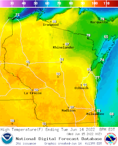
Today has been extremely hot and humid across most of southeastern Wisconsin with lakeshore areas from Port Washington to north of Sheboygan being the exception due to a lake breeze out of the southeast.
A heat advisory is currently in affect for all of southeastern Wisconsin until 8pm on Wednesday, due to heat indexes peaking near 100F. Sufficient to say the miserable heat is expected to stick around going through tomorrow as southerly flow from the Gulf of Mexico advects moisture and heat northward. Even the lake shore communities will likely be in the 80s tomorrow to low 90s assuming the lake breeze does not kick in as it did today.
Highs across most of southeast Wisconsin will be in the low to mid 90s, with heat index values near or possibly exceeding 100F. Dew points will remain in the low to mid 70s as well, so it will feel quite soupy.
Severe Storms Possible
An area of low pressure is currently located over Minnesota which has been the focus for thunderstorm activity across northwestern Minnesota throughout today. A cold front extends southward across southwestern Minnesota into Iowa and Nebraska. A warm front is draped across north central Minnesota and northern Wisconsin, responsible for the stifling temps we have seen today. 
As of right now, a negatively tilted long wave trough digging down from Canada is stationed to our west over the Rocky Mountains. This trough will advect eastward through the next day closer to the Wisconsin area. Both the GFS and EURO computer models indicate that a shortwave trough currently located over Idaho will amplify over Wyoming and move into the Dakotas tomorrow morning. The trough will take on a negative tilt while doing so, providing not only a favorable upper level wind environment for thunderstorm development, but a favorable set up for the storms to potentially become severe.
The Storm Prediction Center (SPC) has issued an enhanced risk of severe weather for most of Wisconsin tomorrow and a slight risk for parts of southeastern Wisconsin tomorrow outside of the enhanced risk.
Looking at forecasted soundings and hodographs there is a general consensus on the storm mode for tomorrow and the general timing of the storms.
Most models indicate that there may be some leftover shower and thunderstorm activity in western and central Wisconsin due to the cold front approaching from the west. Shear is expected to be quite strong, so some storms could become severe earlier in the day but most of this activity will likely stay west of Jefferson and Dodge counties. The morning convection may impact the convection during the afternoon if cloud cover sticks around later into the day but not expecting but interference of afternoon storm potential from any early morning activity that takes place.
As we head into the afternoon and the heat builds, steep lapse rates will develop. We will also see the erosion of the cap as the front approaches from the west. CAPE values will be between 3,000 to 4,000 J/kg. The low level jet is also expected to amplify out of the south heading into the afternoon which will increase shear to the order of 30 to 50 knots. This will provide a better environment for supercell development ahead of the cold front initially. What most models anticipate is that scattered strong thunderstorms that develop will become more linear as they track eastward, and odds are we will be dealing with a Quasi-Linear Convective System across SE WI tomorrow evening. Below is a graphic created by the National Weather Service.
Some discrete supercells may develop ahead of the developing line of thunderstorms as well. The SPC mentions that these tornadoes could be quite strong, hence the 10% hatched risk as depicted below for Jefferson, Dodge, Washington, Fond du Lac, Ozaukee and Sheboygan counties.
Below are the hazard probabilities for tomorrow's storms, including tornado, hail and wind threat.
Tornado threat issued by the SPC for tomorrow. A 10% hatched risk is in effect for most of Wisconsin, meaning that there is a 10% chance of an EF2 or greater tornado tomorrow for the area enclosed in the black circle.
Wind threat for tomorrow. There is a 30% risk for high winds across much of Wisconsin tomorrow.
Hail risk for tomorrow. A 30% hatched risk of large hail is in place for much of Wisconsin.
Storms will likely be weakening by the time they enter Waukesha, Milwaukee, Racine, Kenosha and Walworth counties tomorrow evening. The threat for severe weather will still exist for these counties however, but the chances are not as great. We may see an expansion east of the enhanced risk tomorrow throughout the day so that will be something to look for as well.
Overall, tomorrow could be a rather active day across southeast Wisconsin. From the extreme heat to the possibility of severe thunderstorms tomorrow evening, tomorrow will be a day to monitor the weather closely.

Partly cloudy skies. Very hot and humid. Widely scattered strong thunderstorms possible in the afternoon. Highs in the mid 90s inland, upper 80Fs near the lake. SSW winds 10 to 15 mph, with gusts up to around 25 mph. Large hail, damaging winds, and tornadoes are possible in stronger storms. Chance of storms 30%.
Wednesday Night
Mostly cloudy skies, especially before midnight. Severe thunderstorms likely during the evening, then chance of showers and thunderstorms in the late evening and early morning. Lows in the lower 60Fs. West winds 5 to 15 mph, with gusts up to 30 mph. Large hail, damaging winds, and tornadoes are possible with some stronger storms. Chance of storms 70%.
For more information, please consult the following sites:
https://www.weather.gov/mkx/
https://www.spc.noaa.gov/
https://www.tropicaltidbits.com/


Comments
Post a Comment