2022 Atlantic Hurricane Season Outlook
August 3rd, 2022
By Aidan Cera
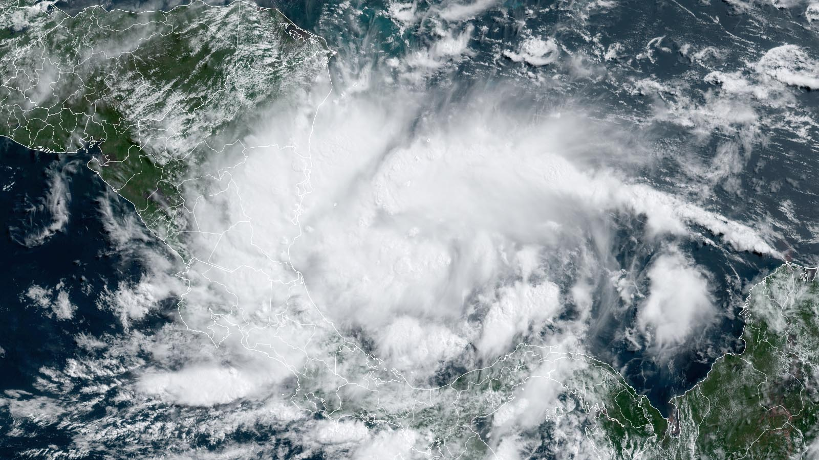
Fig 1. Tropical Storm Bonnie intensifying over the southwestern Caribbean Sea
We are fast approaching the climatological peak of the Atlantic hurricane season. With the typical ramp up of activity only a week or two away, our attention is focusing on the Atlantic. This outlook takes into account current and past conditions across the Atlantic basin since the beginning of the 2022 Atlantic Hurricane Season, ranging from sea surface temperature anomalies to mid level atmospheric dynamics.
Below is my quantitative rough estimate of how many named storms, hurricanes and major hurricanes we could see for the season as a whole.
Named Storms —------------------------------ 14-18
Hurricanes —-------------------------------- 7-9
Major Hurricanes —-------------------------- 3-5
ACE —--------------------------------------- 120-150
ACE = Accumulated Cyclone Energy
Three named storms have already formed, Alex, Bonnie and Colin, all of which were tropical storms.
Below are the probabilities of each outcome regarding the amount of activity expected average wise, including well-below average, below average, slightly below or near average, slightly above or near average, above average and well above average.

Fig 2. Pie chart representing probabilities for the outcome of the 2022 Atlantic Hurricane Season.
The rest of the outlook will look at each individual primary indicator on the level of activity we could see this season.
El Nino Southern Oscillation (ENSO)
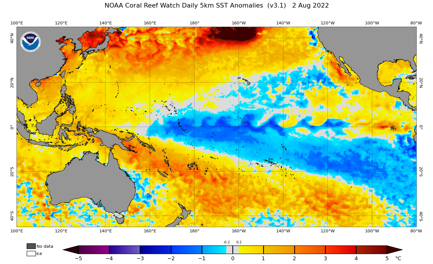
Figure 3. Sea surface temperature anomalies (SSTA) for the Pacific Ocean as of 2 August 2022.
Taking a look at the ENSO state of the Pacific, we can clearly see an ongoing La Nina that has been going since last fall. This La Nina is fairly central based in nature with the coldest anomalies located in the Central Pacific south of Hawaii. Warmer anomalies are present in the Nino 1+2 area, with colder anomalies expanding into the Nino 3 area.
La Nina tends to be a favorable indicator for the Atlantic, since the colder Pacific waters tends to induce subsidence or sinking across the Pacific which decreases the shear over the Atlantic, especially the Caribbean Sea and Tropical Atlantic. However, the warmer anomalies closer to South America appear to be having an El Nino like effect on the Pacific and Atlantic, with a continuous stream of hurricanes developing in the eastern Pacific, a rather abnormal occurrence in La Nina years. This has induced more sinking across the Atlantic as of late which has suppressed overall activity.
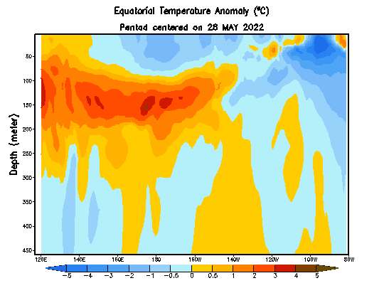
Fig 4. SSTA’s at depth across the equatorial Pacific.
There is some hope for the Atlantic though. Looking at sea surface anomalies at varying depths shows that the downwelling kelvin wave has weakened significantly in the eastern Pacific and is quickly being replaced by cold anomalies, indicating that these anomalies will likely reach the surface fairly soon. This will help shut down the rising cell that has been present over the eastern Pacific since June and create a more favorable environment for the Atlantic in theory. This will also reinforce La Nina most likely through the 2022-2023 winter season.
So in regards to the state of the ENSO, there is a favorable set up for the Atlantic overall assuming the warmer Nino 1 and 2 areas cool in the coming weeks.
Atlantic Multidecadal Oscillation (AMO)
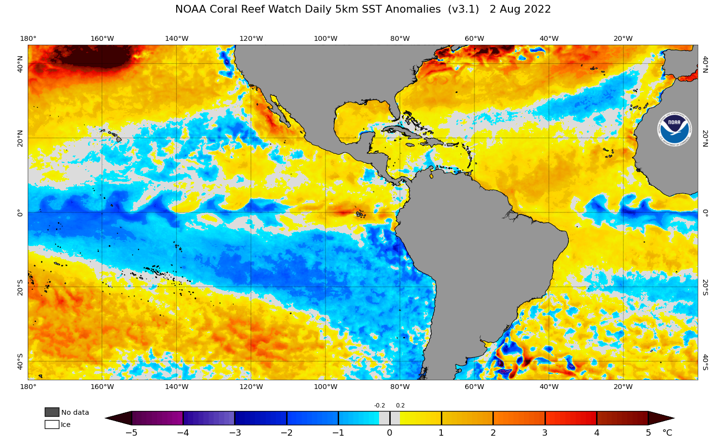
Figure 5. SSTA’s of the western hemisphere as of 2 August 2022 according to the NOAA NESDIS method.
The Atlantic appears to be in more of a +AMO phase than a -AMO phase, which is a favorable indicator overall. Colder than normal waters are present in the subtropics and equatorial Atlantic and warmer waters in the tropical Atlantic forming a rather favorable dipole of SSTA’s. This warm strip in the tropics will favor an increase in instability for tropical cyclones to tap into and more energy available in the water. In fact, according to Dr. Klotzbach at Colorado State University, the tropical Atlantic is running in very near the average SSTA’s during hyperactive Atlantic hurricane season.
The one caveat however, is the cold canary current, especially the colder waters between the Canary Islands and Azores. This pattern tends to increase stability across the tropics due to stable air from this region of the subtropics being advected into the deep tropics due to atmospheric flow off the coast of Africa paralleling the coast north to south. This is likely a major culprit in why we have not seen as much activity in the tropical Atlantic as we have seen in recent years.
However, I do expect a warmer tropical Atlantic to offset this mid level dry air advection once the climatological peak of the season passes by, but this too will likely hinder the Atlantic from reaching its full potential despite a highly favorable SSTA tropical Atlantic profile.
I am personally not expecting this warm tropical Atlantic look to disappear as we head into the peak of the season. The main reason for this is that most reliable long range models indicate that trades will remain weak across the tropical Atlantic in the coming weeks. These weak trades will limit cold water advection from increasing depths of the Atlantic due to lower mixing of the water induced by wind.
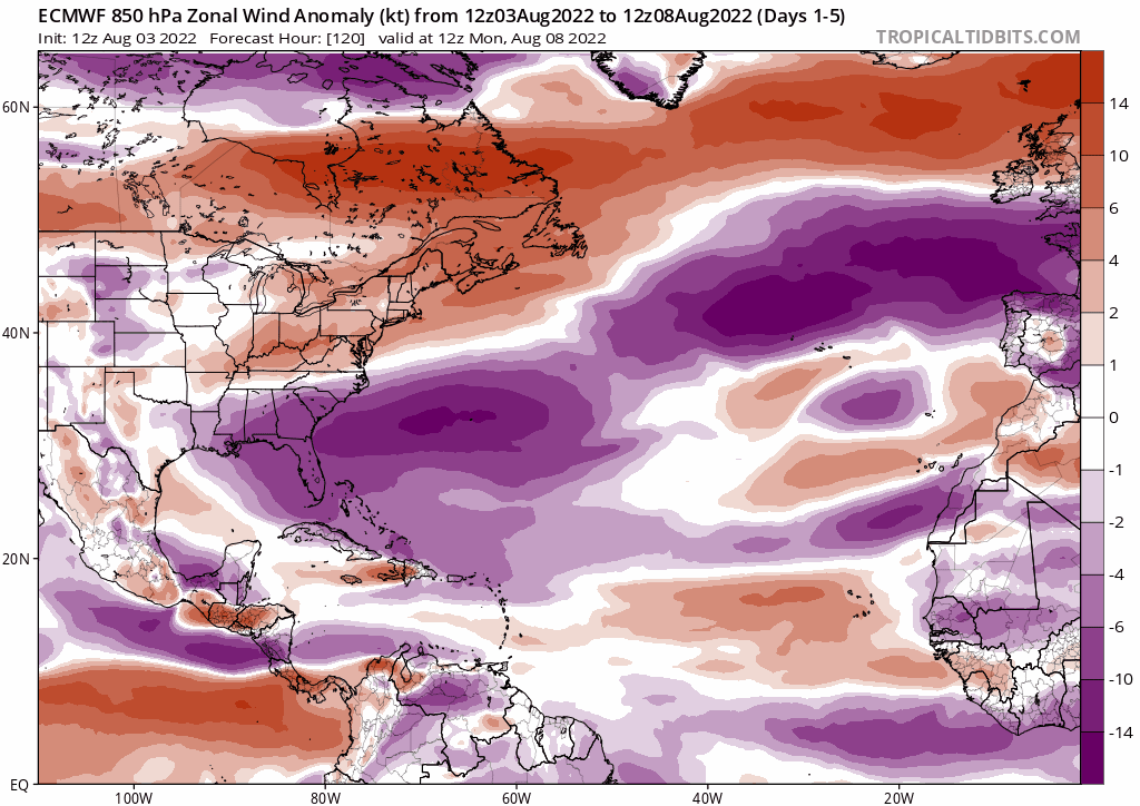
Figure 7. ECMWF forecast for trades across the Atlantic basin. Purple represents enhanced easterly trades and oranges represent enhanced westerly trades.
The ECMWF seems fairly locked on to the idea that trades will be weaker across the tropical Atlantic overall in the coming weeks. This favors the tropical Atlantic warming up as we approach the peak of the hurricane season, which is certainly a favorable look for the Atlantic overall.
West African Monsoon (WAM)
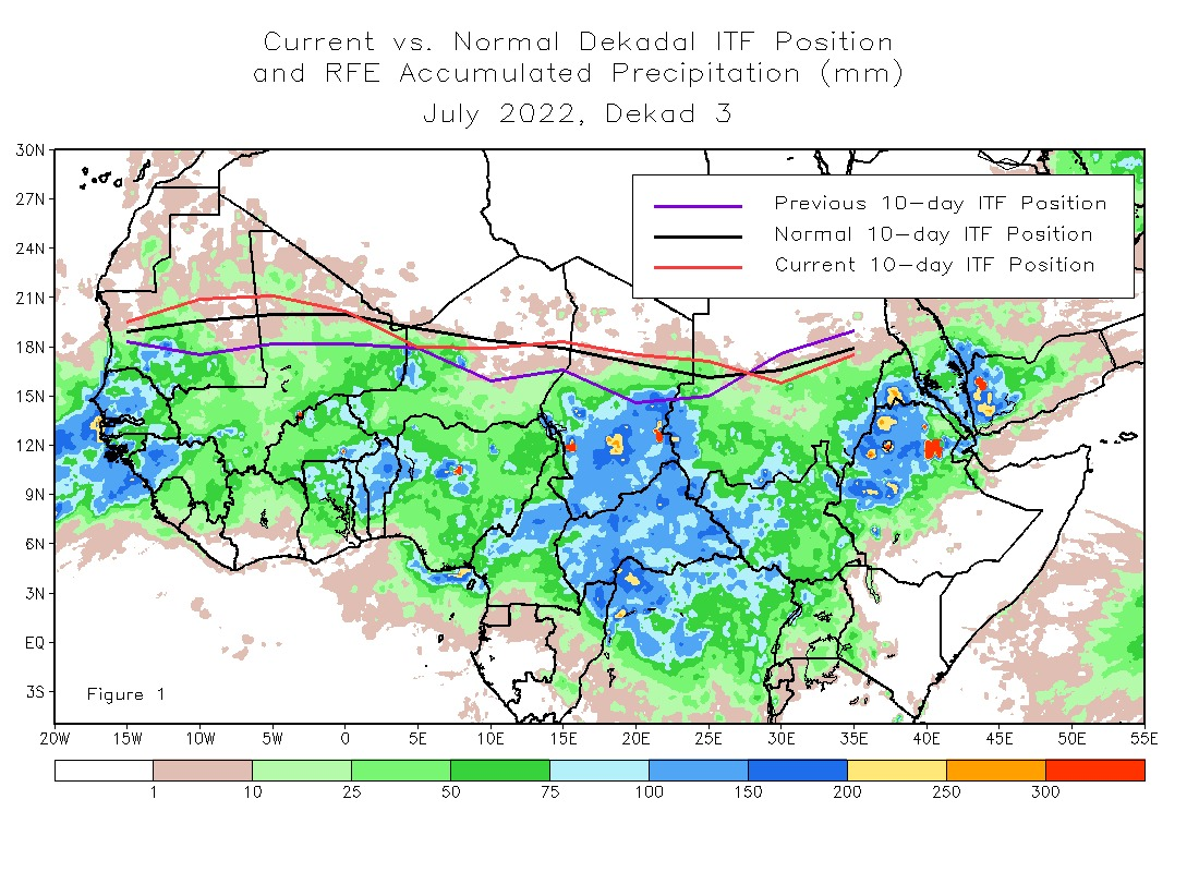
Figure 8. The Intertropical Convergence Zone location as of the last 10 days over Africa.
The West African monsoon has been fairly active this year as it has been in several years prior. The Intertropical Convergence Zone is currently located slightly further north than average over the last 10 days as compared to the average 10 day mean at this time of year. A more displaced ITCZ to the north sends African Easterly Waves into the Atlantic at higher latitudes which would expose them to more dry air and colder sea surface temperatures. However, these waves will be kept from developing until they reach further west where conditions tend to be more favorable so this is overall a good look for the Atlantic if waves are more likely to reach the Caribbean Sea and Gulf of Mexico.
Wave Breaking
Wave breaking is a process that occurs in the subtropics or mid latitudes during any time of year. Wave breaking is when a trough of low pressure advects southward over the Atlantic Ocean and the southern portion of the trough is pinched off by the jet stream. Once pinched off, this lobe of lower upper level pressure can become a Tropical Upper Tropospheric Trough (TUTT) in many instances. A TUTT is highly detrimental to tropical cyclone development most of the time due to mid level dry air advection and shear circulating the upper level low. These TUTT’s are the leading cause of shear in the Atlantic during the late summer and early fall in La Nina years, and in recent years they have been more prevalent. We have not seen many TUTT’s in the Atlantic this year, however, the other detrimental affect of wave breaking for the tropics has been highly prevalent in regards to the dry air mid level intrusions in the deep tropics as mentioned before. This has likely been the primary reason for the Atlantic being so unfavorable thus far despite a favorable MJO phase overall (more on this later).
This wave breaking effect has lasted longer than it typically does across the Atlantic this year, and may be an indicator that the Atlantic Ocean is not as favorable as expected which is why the season has been on the quiet side compared to the last few years. This phenomena was the leading culprit on why the 2013 Atlantic Hurricane Season never got going on top of a salinity crash in the Atlantic. It is highly unlikely we will see this wave breaking take place into the peak of the hurricane season, especially to this extent of which it has been occurring as of late. The possibility is certainly there which is one of the other reasons I have held back on expecting a well above average season.
Madden Julian Oscillation (MJO)
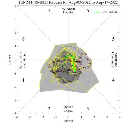
Figure 6. Madden Julian Oscillation track since late June on a global scale.
The MJO has been bouncing back and forth through the Atlantic, the Indian Ocean and Maritime Continent over the last month or so. Typically speaking, these phases are rather favorable for the Atlantic, however, due to a variety of conditions localized to the Atlantic, we have not seen any tropical cyclones take advantage of the rather buoyant environment created by the MJO over the Atlantic, Africa and Indian Ocean.
The MJO is expected to break down in the coming days and will manifest more so in the form of several Convectively Coupled Kelvin Waves (CCKW’s), which when passing through the Atlantic still fosters development. Many of the long range models such as the CFS, GFS and ECMWF show rising air taking hold of Africa and the Indian Ocean by the end of the month. In theory this would favor the Atlantic if other conditions allow. This rising air will likely not be the form of a standing wave itself like we have seen in recent years, but in the form of several CCKW’s. This intraseasonal pattern does not favor long duration tropical cyclone outbreaks which may not allow the Atlantic to reach its full potential once the peak of the season arrives.
Mostly this will mean tropical cyclone outbreaks will be rather sudden and short lived but we will likely not see continuous intense tropical cyclone activity over the Atlantic.
Overall, the rising air forecast over Africa and the Indian Ocean favors a ramp up in activity once we get closer to the climatological peak of the hurricane season.
Summary
Overall, a near to slightly above average hurricane season is favored given the current, past and projected conditions of the Atlantic. The ENSO, AMO, WAM are rather favorable overall for increased Atlantic activity, however, there are some caveats which will likely prevent the Atlantic from reaching its full potential in regards to all three of these indicators, such as the warm Nino 1+2 area, or the quasi +AMO.
It appears the MJO phase will be rather favorable for the Atlantic periodically at the very least throughout the season, and I do expect that while not perfect, the state of the ENSO, AMO, WAM and MJO will effectively lead to a slightly above normal Atlantic hurricane season. However, if the wave breaking continues into the peak of the season to the extent it has of late, and we continue to see mid level dry air intrusions in the deep tropics, season totals will likely take a major hit.
On the flip side, conditions may improve as we dive further into the peak of the hurricane season which is why above average is still certainly on the table IF the AMO takes on a more traditional + state and the ENSO takes on a more traditional - state.


Comments
Post a Comment