Posts

Showing posts from April, 2023

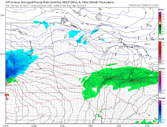
Details on Tomorrow's Storm

Image
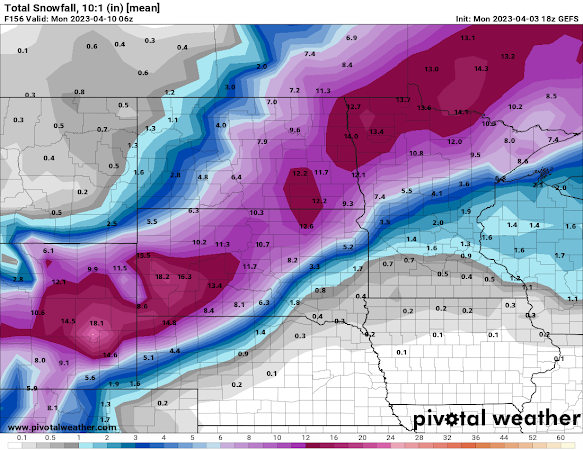
 Details on the Tuesday-Wednesday Storm by Aidan Cera Figure 1. GEFS Ensemble mean snowfall forecast through Wednesday afternoon. Details have become more clear with regards to the system expected to impact the upper Midwest Tuesday through Wednesday afternoon. Everything from blizzard like conditions to the conditional threat for severe thunderstorms are expected dependent upon location of course.  Figure 2. GFS 850 hPa temperature, temperature advection, frontogenesis and wind. Red contours represent temps above freezing, blue contours represent temps below freezing. Red shading represents warm air advection, blue shading represents cold air advection. Purple contours represent frontogenesis. Wind barbs are also plotted. A warm front is expected to amplify as it tracks northward across Iowa and into Minnesota tomorrow morning through the afternoon. Associated warm air advection will lead to increasing temperature and dew points across the entire forecast region (Minnesota, Wisconsin,

Another Potent System Incoming

Image
 Another Potent System Incoming this Week By Aidan Cera  Figure 1. GFS 18Z 04/02 output valid Monday night through Wednesday morning. We are finding ourselves facing another powerful storm system that is expected to track across the upper Midwest Monday through Wednesday Night. Like the system last Friday, this storm is expected to bring a little bit of everything to the Midwest from blizzard like conditions in Dakotas and northwestern Minnesota to a tornado potential down in Iowa. This is still considerable uncertainty in what exactly this storm will do so this discussion is going to focus more on the wide scale pattern and the general idea of what is expected to take place and where.  Upper-level Pattern Figure 2. EPS Ensemble 12Z 04/02 run Sunday through Thursday  A trough is expected to deepen as it traverses the Pacific Northwest and Rocky Mountain region Sunday night through Tuesday. The deepening trough is expected to lead to the development of a jet max ahead of the trough whic