Posts

Showing posts from July, 2023

July 28th Central Minnesota Weather Discussion

Image
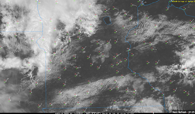
 July 28th Central Minnesota Weather Discussion By Aidan Cera  The heat and humidity is sticking around yet another day. Temperatures are currently in the low to mid 80Fs across much of central Minnesota with dew points in the mid 60Fs to low 70Fs, making it another oppressively humid day. Fortunately we are no longer in excessive heat criteria anymore anywhere across central Minnesota so it won't be as miserable outside but still, not comfortable either though.  It does look like more relief is coming to start our weekend tomorrow with highs in the low 80Fs and dew points a bit lower so we are expected to have a short break before the heat returns next week.  Fig 1. Satellite imagery with surface observations across Minnesota as of around 1:15 PM CST July 28th, 2023. We do have some shower activity making its way into Minnesota from South Dakota currently and moving into Todd and Morrison counties as of around 1 PM CST. These showers are not really expected to produce much in term

July 27th Central Minnesota Severe Weather Discussion

Image
 July 27th Central MN Severe Weather Discussion By Aidan Cera Fig 1. Storm Prediction Center severe weather outlook for Thursday, July 27th 2023 issued at 1612Z (Zulu time).  Today has the potential to be a significant weather day across central Minnesota. The Storm Prediction Center has issued a Enhanced Risk of severe weather for potions of northern Minnesota and northern Wisconsin and a Slight Risk for a good chunk of eastern and central Minnesota and northern and central Wisconsin for today. While the types of severe weather expected varies from region to region, this discussion will primarily focus on the threats across central Minnesota.  Fig 2. Weather Prediction Center Surface Analysis Issued July 27th 1500Z.  Looking at surface analysis, there is a warm front draped across central Minnesota responsible for the advection of very warm and moist air into our area. Temperatures are mostly in the upper 80Fs to lower 90Fs across central Minnesota with dew points at a miserable level

July 25th Central Minnesota Weather Discussion

Image
 July 25th Central Minnesota Weather Discussion By Aidan Cera For the first time in a long, long time, I have quite a bit to talk about today with regards to both the excessive heat across central Minnesota and the continuing severe storm risk through much of this week. The Heat   Fig 1. NWS Twin Cities Maximum Temperature Forecast Through Monday 07/31 For Central/Eastern Minnesota and Western Wisconsin. Yesterday was quite toasty for central Minnesota with highs reaching into the mid to upper 80s for a decent chunk of the area, at least before the scattered thunderstorms blew up and multiple outflow boundaries and cold pools were spread across the area. Today will be even warmer without any afternoon thunderstorm activity expected. Given the abundant sunshine, highs today should climb into the low to mid 90Fs with dew points in the mid to upper 60Fs. These high temperatures and dew points will yield heat indices near 100F or so. Given these conditions, it is highly recommended that an

July 19th Central Minnesota Weather Discussion

Image
 July 19th Central Minnesota Weather Discussion By Aidan Cera Figure 1. Weather Prediction Center 1500Z Surface Analysis. Good afternoon central Minnesota. This discussion is going to be the more brief side since thinking really hasn't changed a lot with regards yesterday's discussion other than many areas are much less likely to see rain this afternoon than before. Yesterday I discussed that it all comes down to two things, 1.) when the cold front comes through and 2.) how much dry air is lurking around.  Addressing the question of cold front placement, timing has been postponed slightly which means the cold front is further west than I anticipated it being by this time. This works to our advantage to see some thunderstorm activity this afternoon across a decent chunk of central Minnesota. However, drier air seems to be outracing the cold front as many mesoscale models have been predicting since yesterday and should advance across much of central Minnesota before convective in

July 18th Central Minnesota Weather Discussion

Image
 Central Minnesota July 18th Weather Discussion By Aidan Cera Figure 1. Storm Prediction Center Day 2 Outlook issued 12:30PM CST. Good afternoon central Minnesota! The main story I want to cover today is that of the severe weather risk tomorrow across portions of our area. The SPC has issued a slight risk of severe weather has been issued for Benton, Mille Lacs, Sherburne, Wright, Meeker, McLeod, Sibley, Carver and portions of Stearns, Renville and Morrison counties. All hazards of severe weather are possible including large hail (15% hatched), damaging winds (15%) and a isolated tornado or two (2%).  Figure 2. ECMWF 250mb Wind Speed/Streamlines (kt) & MSLP Extrema (mb) 06Z run. Image courtesy of tropicaltidbits.com From a synoptic viewpoint, a positively tilted shortwave trough is expected to advect eastward across northern Minnesota tomorrow into tomorrow night. This is expected to lead to amplified upper level flow and a appreciable increase in wind with height. Positive vortici

July 13th 2023 Central Minnesota Weather Discussion

Image
July 13th Central Minnesota Weather Discussion The Case of the Hudson Bay Low  By Aidan Cera Good afternoon central Minnesota! I want to apologize for my lack of any blog entries as of late, between vacation for the holiday and then dealing with work and other responsibilities I have not had as much time as I usually do to make any posts. Looking ahead over the next few weeks my entries may be rather here and there given more vacation time coming up but will try my best to post as often as I can :) Figure 1. Storm Prediction Center Day 1 Outlook Issued 10:30 AM CST. I want to start this discussion by looking at the Storm Prediction Centers (SPC) Day 1 Outlook shown above. Parts of central Minnesota including Renville, Kandiyohi, Meeker, Wright, Sherburne, McLeod, Carver and Sibley counties are in a slight risk of severe weather, specifically for damaging winds through tonight. The rest of central Minnesota is under a Marginal risk of severe thunderstorms primarily for large hail and da