July 13th 2023 Central Minnesota Weather Discussion
July 13th Central Minnesota Weather Discussion
The Case of the Hudson Bay Low
By Aidan Cera
Good afternoon central Minnesota! I want to apologize for my lack of any blog entries as of late, between vacation for the holiday and then dealing with work and other responsibilities I have not had as much time as I usually do to make any posts. Looking ahead over the next few weeks my entries may be rather here and there given more vacation time coming up but will try my best to post as often as I can :)


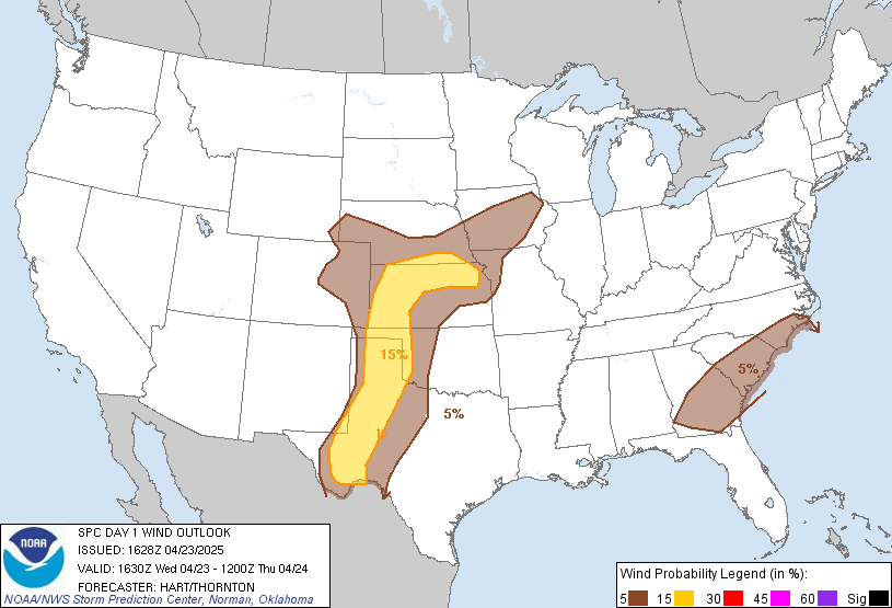
Figure 1. Storm Prediction Center Day 1 Outlook Issued 10:30 AM CST.
I want to start this discussion by looking at the Storm Prediction Centers (SPC) Day 1 Outlook shown above. Parts of central Minnesota including Renville, Kandiyohi, Meeker, Wright, Sherburne, McLeod, Carver and Sibley counties are in a slight risk of severe weather, specifically for damaging winds through tonight. The rest of central Minnesota is under a Marginal risk of severe thunderstorms primarily for large hail and damaging winds.
This is not expected to be a widespread event per the usual story of this incredibly inactive summer. Some areas will see localized heavy rain while areas prone to not seeing rain with scattered events will likely remain dry. Sauk Centre, Willmar, Little Falls have been very prone to lucking out with these types of setups will St Cloud, Foley areas specifically have been left in the dust almost every scattered rain event. I see no reason to see that trend discontinuing today so eastern Stearns county, Benton county and Mille Lacs county should be dry for today...which coincides with where drought conditions are the most extreme. I plan to go into the reasoning behind this later in this discussion when I talk about the ever strengthening drought across our region.

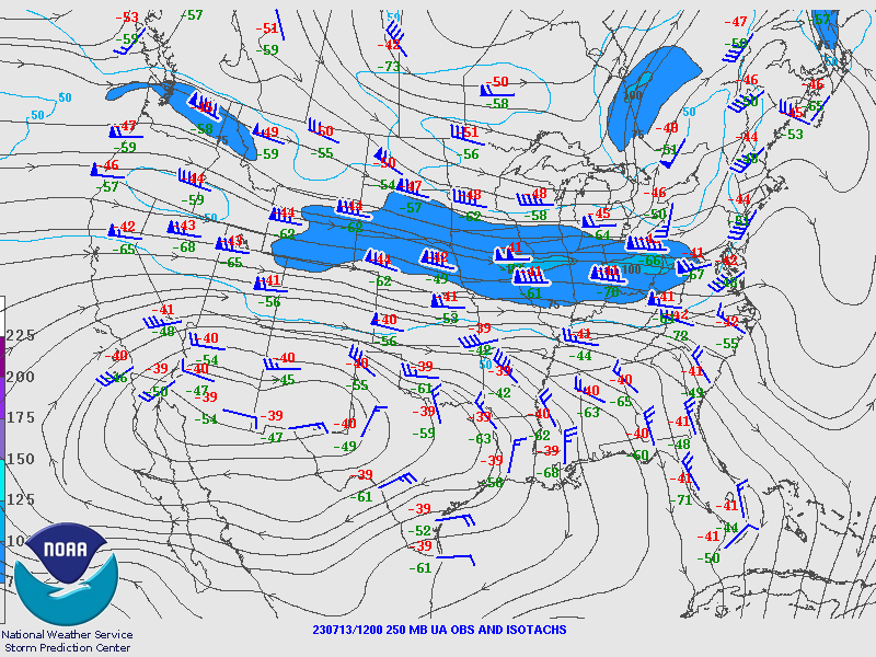
Figure 2. SPC 250 mb wind chart for Thursday July 13th, 2023 at 7:00 AM CST.
From a synoptic perspective, the chart in Figure 2 shows the subtropical jet over South Dakota, Nebraska through Iowa, Illinois and into Indiana and Ohio. Upper level winds along the jet max to Minnesota's south are out of the WNW along the southside of a stout upper level low stationed over Hudson Bay.
Figure 3. EPS Ensemble 250 mb wind forecast for 06Z July 13 2023.The low over Hudson Bay has been advecting cooler air into our area for the last few days and I expect that to continue through at least the middle of next week. While next week initially looked as if it could be a very hot week, models are now in agreement that the Hudson Bay trough will not allow much northward propagation of a building ridge over the southern high Plains. This means that we will likely see cooler temperatures and drier weather conditions with the subtropical jet squashed to the south. Therefore the only real chance of precipitation comes today in associated with a few weak shortwave troughs advecting from Canada providing some weak forcing.
Morning soundings show a decent but shallow thermal inversion close to the surface which should erode away with the daytime heating. Given that we have cumulus developing across parts of central Minnesota, many areas seem to have already reached their convective temperature. Therefore I don't really see storms having any issues firing heading into this evening once the forcing from those shortwaves arrives. As stated before though, without any appreciable frontal passage, lift is going to be very minimal and therefore storm coverage will be minor, many areas will likely not see rain at all.
Temperatures today are expected to be in the mid 80s across the region with generally mostly sunny to partly cloudy skies given the development of cumulus clouds.
Clouds increase tonight as weak forcing enters the area along with any shower or thunderstorm activity that does take place. The primary severe threat if any storms manage to become severe would be damaging winds and large hail. Given the shear being 30-40 kts, I would expect at least a few severe warned storms this evening so it would be a good idea to check back with the NWS and radar for the latest weather updates for any evening plans.
Tomorrow some weak forcing will still be present as a cold front slides through but again, not expecting anything widespread. Still expecting plenty of sun tomorrow, however, as the day progresses, that sunshine is going to be dimmed by yet again another bout of dense Canadian wildfire smoke. Given the nature of cold air advection and large scale sinking motions on the backside of cold fronts and troughs, I do expect smoke to reach the surface by tomorrow evening so air quality is going to go down for sure throughout the day. Air Quality alerts have been issued by the NWS and will remain in effect until at least Saturday afternoon based on the latest HRRR model runs showing a thick plume of smoke across Minnesota through that time.
Behind the trough this weekend, cooler and polluted air will flood int for the weekend into early next week. Highs will struggle to approach 80F for many areas across central Minnesota through early next week, so below normal temperatures in short as indicated by the animation in Figure 3. I think (hope) the smoke will get a little better as the weekend progresses, especially into Sunday and Monday of next week, but I wouldn't get my hopes up to high given that we will still be in a NW flow pattern during that time. In fact, it appears that we could be in a NW flow pattern a majority of the next two weeks with very little in terms of rain chances. Smoke likely won't be a concern for the whole forecast period but will likely be making occasional trips back down into our area through the end of next week into the following weeks as well.

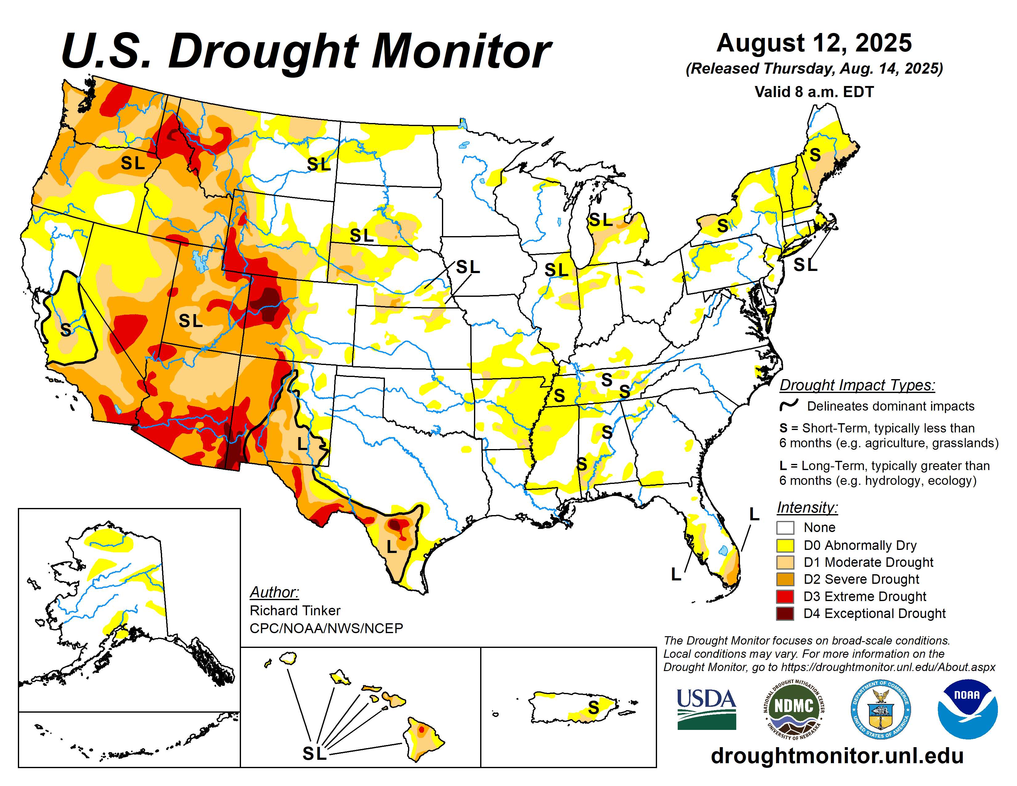
Figure 4. Climate Prediction Drought Map for July 11th, 2023.
So what about our drought conditions? We did see some highly beneficial rain this past Tuesday that was enough to soak the lawns but not enough to really make a dent in our significant drought that is spreading across the area.
So the main question likely is....why are we so dang dry!?!?
Well, there are a combination of factors that have lead to us seeing the quietest summer I can ever remember seeing a lot of the blame goes to the unusual nature of the polar and subtropical jets. As of currently, the subtropical jet is struggling to make it north into Minnesota, which, by this time of year, it should be up in southern Canada. This explains why we have had such low temperatures as of late compared to where they should be and also why it has been so dang dry all summer. We did not and still are not seeing any of the moisture advection from the Gulf of Mexico that we should be seeing this time of year and should have been seeing back in May.
This has resulted in very dry conditions across our area. Low moisture has also stunted crop growth and has killed off most of the lawns around our area, which means less evapotranspiration is taking place, which means even less moisture in the air. During the summer, Minnesota receives its moisture primarily from crops and partially from the Gulf of Mexico and the Pacific. Since we haven't seen much rain since May, the crop moisture yield is almost nonexistent, and since the subtropical and polar jets are so displaced to the south this year with a persistent omega blocking pattern to our west, there is no Atlantic and Pacific moisture advection taking place either. This has left us literally in the dust in terms of appreciable precipitation chances minus what we saw on Tuesday.
For a brief moment it seemed a ridge of high pressure would set up to our southwest and lead to a ring of fire like pattern, where Pacific and monsoonal moisture had the potential to make it into Minnesota, raising the humidity around here and amount of water in the air any boundaries could squeeze out and give us rain. Now that high is expected to be flattened south due to the anomalous trough circulating over the Hudson Bay. This will also keep the subtropical jet well to our south for the foreseeable future. As a result, there seems to be no appreciable pattern change in sight as we head through the remainder of July. In fact, given that it is already the middle of July and the subtropical jet has yet to make it into Minnesota, it is becoming increasingly likely that we may not see it reach into Canada at all this year. If this holds true, a very dry future lies ahead through the rest of the summer with no appreciable rain in sight. Bottom line is this: as long as that subtropical jet stays over us or to our south, not much is going to happen around here, and as long as that Hudson Bay trough sticks around, the subtropical jet won't be able to make progress north.
For now, expect drought conditions to worsen, wildfire smoke to linger, and unseasonably cool temperatures to stick around through the next 2-3 weeks. Really isn't going to feel like summer out there that is for sure, or at least a summer we can enjoy.


Comments
Post a Comment