Father's Day Central Minnesota Weather Update
Central Minnesota June 18th Wx Update
by Aidan Cera
Figure 1. NEXRAD Base Reflectivity for central Minnesota on June 18 2023 at 1420Z CDT.
WE HAD RAIN THIS MORNING!!!!!!!!!!!!!!!!!!!!!!!!!!!!
After weeks of no rain, we finally saw some light but very beneficial rainfall across most of central Minnesota this morning. The rain has since come to an end, but there have been some widely scattered heavy showers across Kandiyohi and Sherburne counties but most places have not been touched by these hit or miss cells.

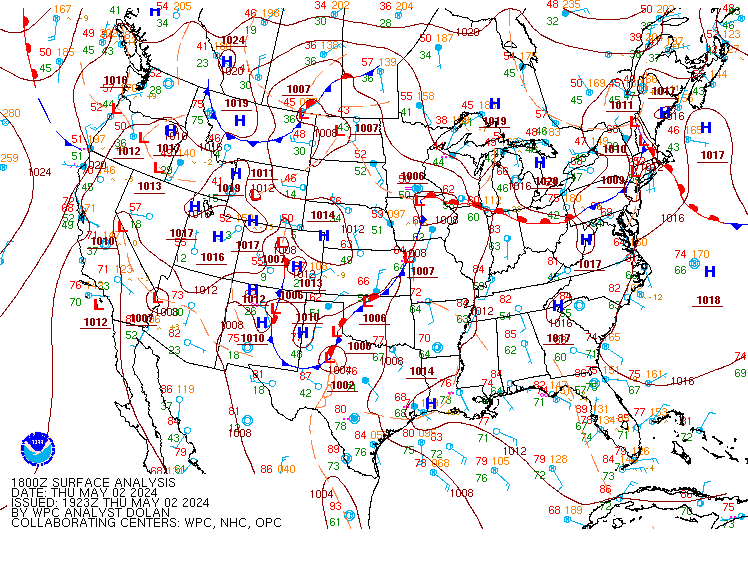
Figure 2. Weather Prediction Center 1800Z surface analysis for June 18 2023.
In terms of surface analysis, we are still in the vicinity of a surface low to the south which is providing just enough lift to spark off those widely scattered showers and thunderstorms. This low is going to gradually weaken and drift east as the rest of today progresses into tonight. A good deal of cloud cover is expected to stick around behind the low as low level moisture is still firmly in place and there is still some weak lifting. Due to the cloudiness, lows are only expected to get down to near 60F tonight (between 58F and 64F generally). Still cannot rule out a stray shower or thunderstorm in the area due to any forcing strong enough to lift some of those saturated air parcels higher into the atmosphere but overall I'm expecting mostly dry conditions.
For Monday, any remaining cloud cover will quickly clear out and give away to sunny, hot and muggy conditions. Highs are expected to approach 90F across central Minnesota and possibly surpass 90F by several degrees. Moisture advection is expected to be limited due to a cutoff low to the south that I will discuss more in detail later in the discussion. This will make the heat throughout the entire week a lot more bearable.
As we approach the end of the week, the cut off low to the south is expected to slowly weaken and work its way east which will also cause the ridge of high pressure aloft to break down. This will be a slow process so we won't see a weather pattern change all at once, but it does look like next weekend could feature a pattern change that leads to a rain chance return to central Minnesota. While not worth going into detail all too much given the distance of time between then and now, it looks like a negatively tilted shortwave trough will advect across the northern Plains and across Minnesota next Saturday/Sunday. The GFS, ECMWF and CMC all show significant lift and precipitation chances returning to Minnesota during that time and the possibility of a widespread rainfall event as well. I'm not getting my hopes up to high on this given that it is still a ways out, however, it is something I will be keeping an eye on in the coming week and will continue to mention in each forecast update most likely.
I hope everyone has had a wonderful Father's Day and has a great start to the work week tomorrow!
Below is the general 48-hr forecast created earlier today for central Minnesota.


Comments
Post a Comment