Flood Watches In Effect, Multiple Storm Rounds Next Few Days
06/21/24 Southeastern Wisconsin Weather Outlook
Aidan Cera

Good morning southeastern Wisconsin. I apologize for not making many posts this week, schedule has been fairly busy with preparing to move back up to Minnesota here shortly.
As the title says, a Flood Watch has been issued by the National Weather Service office of Milwaukee for portions of southeastern Wisconsin. The counties in this watch include Waukesha, Washington, Fond Du Lac, Dodge and Jefferson Counties. This watch runs until tomorrow, Saturday June 22nd 7:00 PM CDT. Keeping an close eye on the weather the next 24-36 hrs will be important if you plan on traveling or have any outdoor plans. Excessive rainfall will certainly be possible during this time window, and if any flooding near rivers is likely or may happen, exercise caution around these areas in case flooding does indeed occur. Keep tabs on the National Weather Service of Milwaukee and the information they put out via their website, X(formerly Twitter), as well as your local news weather stations.
Now, into the logistics of the forecast...

As of this morning, there is currently a warm front right over southeastern Wisconsin, indicated by the shift in the winds from east to southerly as well as the sharp increase in dew points south of the front. Unfortunately, this does mean that our dew points are going to increase the next several hours, which means a return of the heat and humidity, although I do not currently expect temperatures to climb as much as they did early this week (more on that in a second).
This warm front is forecast to park itself over southern Wisconsin over the next 24-36 hrs, which will provide the means to kick off multiple rounds of shower and thunderstorms from South Dakota all the way across the Upper Midwest. Currently we can see multiple complexes of showers and thunderstorms tracking generally eastward on the northern periphery of the warm front. While this activity should stay north of the warm front predominantly, any shifts in the warm fronts position could alter how much rain we see today into tonight. A shift south would mean more rain, while a shift north would mean less rain. Regardless of positioning, I do think energy ripples emitting from these storm complexes will make it into southern Wisconsin later today and will likely spark scattered showers and thunderstorms.

It is certainly worth noting that there is a Marginal Risk (1 out of 5) for all of southeastern Wisconsin for storms that develop later this afternoon into the evening. The primary threats with these storms will be damaging winds and heavy rainfall, but I cannot rule out some hail or even an isolated tornado or two. As the National Weather Service indicates, the best chance of showers and thunderstorms will be after 2 PM and before 9PM-10PM. The main activity will likely be between 3PM-4PM until 7PM-8PM.

Because these storms may develop over the same locations and track over the same locations through this time frame, the NWS is cautioning that flash flooding may be possible. It really is no secret that our area has seen a lot of rain as of late, which only makes this outcome more likely. The NWS of Milwaukee does a great job at summarizing their expectations for any severe weather event such as this one, and I highly encourage folks to check out their website and do some looking around. Great graphics like the one I have posted above sum up all the information you need when it comes to the flood threat today and tomorrow are currently up on their site. Feel free to check them out!
With these storms, rain totals increase the further west you go under the assumption that Lake Michigan does it's duty of killing off all the storms before they reach it. Given the southerly flow though, I hesitate to guarantee this will happen in all honesty. Rain totals are likely to drop off the further east you go, but the main uncertainty right now is just how much they drop off. If you are in the counties listed above for the watch however, you are the most likely to see significant rains and persistent thunderstorm activity through the evening.

Temperature forecasts for today are a bit tricky, and will largely depend on the extent of cloud cover. Official forecasts call for highs in the upper 70ºF's, while most model guidance calls for mid 80ºF's across much of southeastern Wisconsin. With the ample sunshine many locations have seen thus far today, have decided to go on the high end, with highs likely reaching into the lower to mid 80ºF's for a majority of our area, with cooler temperatures possible in Fond Du Lac and Sheboygan counties, closer to the ongoing storm activity. It will also be quite muggy, with dew points in the mid to upper 60ºF's, potentially nearing 70ºF later today, especially for our southern counties.
Tonight, showers and thunderstorms should come to an end at least for a little while. Thinking a good deal of cloud cover will be sticking around through the night, so do not expect lows to drop any lower than the mid 60º to upper 60ºF's. The humidity will stick around as well, so crank up that AC if you have it!

Shower and storm chances return early tomorrow morning. The main question is how early these storms can start to develop south of any pre-existing activity rolling out of Iowa and Minnesota. Odds favor storm activity starting after daybreak tomorrow and lasting through most of the day if the warm front can set itself up right. This would translate to multiple rounds of showers and thunderstorms throughout the day. Persistent cloud cover should keep a cap on our temperatures from climbing above 80ºF, but if we are able to catch a break in the afternoon and get some sunshine before the cold front arrives, temperatures may climb into the low to mid 80ºF's once again.
Once we get into the afternoon and evening, the above mentioned cold front will swing through. This is when I believe we will see out greatest chances of severe thunderstorms, especially for our western counties.
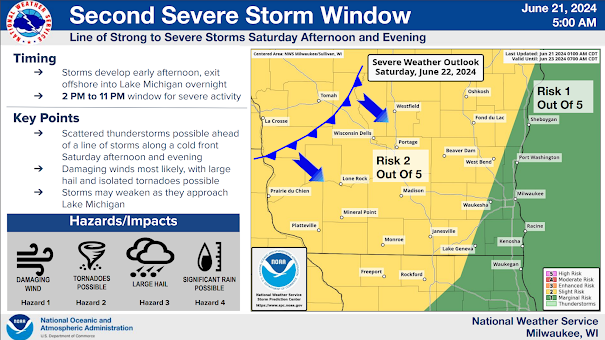
The Storm Prediction Center has much of southeastern Wisconsin in a Slight Risk (2 out of 5) for severe thunderstorms for Saturday afternoon into the evening hours. All modes of severe weather will be possible, including large hail, damaging winds, tornadoes and excessive rainfall. Severity of these storms may decrease as they head southeastward thanks to Lake Michigan, but to tell the truth I am not entirely sold on this being a guarantee. The reason being is the strong southwesterly winds ahead of the cold front transporting copious amounts of low level moisture into the storms as they track through. The lake has more of an influence if winds are out of the east undercutting the moisture coming up from the south. But if winds are not going to be coming from the east, how much of an effect on the storms will the lake truly have? This is why I caution our lakefront communities from thinking storms will no longer be severe as they reach these communities. It could happen but is not a guarantee.

Majority of global and smaller scale models show a potent line of thunderstorms developing along the cold front starting in western Wisconsin later in the afternoon and working their way across southern Wisconsin Saturday evening. This will only add the rain totals we see up to this point.

Overall, 1"-2" of rain is possible across majority of southeastern Wisconsin by the time these storms move out of the area late Saturday evening into the overnight hours. Some locations across Dodge, Jefferson and Fond Du Lac counties may say up to 2.5"! Once these storms exit, the flash flood watch will be allowed to expire, but river flood warning or watches may still be in place since peak river flood stage usually lags behind peak rainfall.
Lows tomorrow night are not expected to dip below the mid 60ºF's once again, but the mugginess will start to clear out, making for a much more comfortable night than Friday night. Heading into Sunday, much more pleasant weather arrives with cooler temperatures (upper 70ºF's to lower 80ºF's) and less humidity to deal with. Sunshine is expected as well, but cannot rule out a pop of shower or thunderstorm during the afternoon with another area of low pressure passing us by to the north.
Monday looks likely another nice day, with slightly warmer high temperatures (low to mid 80ºF's). Monday storm chances do return well after midnight, and will linger into Tuesday. There is a lot of uncertainty when it comes to how long storm chances linger into Tuesday and how warm and muggy we get. Some models show hot and humid conditions returning full force, with storm chances around through Tuesday evening, while other models show the cold front passing through Tuesday morning and storms exiting by afternoon. This would also mean less heat and humidity for the day on Tuesday. There is great uncertainty with this system though, so check back in a few days for more information.
I think we may finally quiet things down slightly by the middle of next week, with cooler temperatures return (70ºF's) and less muggy air, with plenty of sunshine as well, so that is something to look forward to while we deal with the heat, mugginess, and storms the next few days.
In summary, storms will be possible through tomorrow night for our area, with severe weather and flooding being a potential concern. Widespread 1-2" of rain may fall across our area during that time frame, with even more rainfall totals possible further north and west. We get a short break from the storms, heat and humidity Sunday and Monday before another round of it arrives for Tuesday. Keep up to date with severe weather and flooding hazards via your local NWS office as well as local news stations. Plenty of places to get your info to stay up to date :)
Have a fantastic end of your workweek and start of the weekend. Stay safe out there folks!
Forecast Summary
Friday
Partly sunny. Scattered showers and t-storms developing during the afternoon. Highs in the low to mid 80ºF's. Winds E at 5 mph. Some storms may be severe, with damaging winds and small hail. Rainfall totals may reach 0.25-0.5". Chance of t-storms 60%.
Friday Night

Scattered showers and t-storms possible during the evening, then mostly cloudy skies overnight. Lows in the low to mid 60ºF's. ESE winds 5 mph. Rainfall totals mays reach 0.25". Chance of storms 50%.
Saturday

Showers and t-storms likely. Highs in the upper 70ºF to lower 80ºF's. SW winds 5 to 15 mph. Rainfall totals 0.5"-1.25" possible. Chance of t-storms 70%.
Saturday Night

Strong t-storms in the evening, the clearing skies overnight. Lows in the mid 60ºF's. SW winds 10 to 15 mph shifting NW overnight. Rainfall totals 0.5"-1" possible. Some storms may be severe with large hail, damaging winds, tornadoes, and heavy rainfall. Chance of t-storms 80%.
Sunday

Sunny to partly cloudy. A stray shower or thunderstorm is possible during the afternoon. Highs in the upper 70ºF's to lower 80ºF's. NW winds around 10 to 15 mph. Chance of t-storms 20%.
Sunday Night

Mostly clear skies. Lows in the lower to mid 60ºF's. NW winds 5 to 10 mph.
Monday

Mostly sunny skies. Highs in the low to mid 80ºF's. Winds S at 5 mph.
Monday Night
Clear before midnight, then scattered showers and t-storms after midnight. Lows in the mid 60ºF's. S winds around 5 to 10 mph. Chance of t-storms 50%.
Tuesday

Scattered t-storms. Highs in the upper 80ºF's to lower 90ºF's. Winds SW at 5 to 10 mph. Chance of t-storms 50%.

Comments
Post a Comment