Posts

Showing posts from June, 2022

Busy week in the tropics

Image
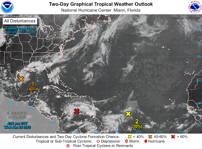
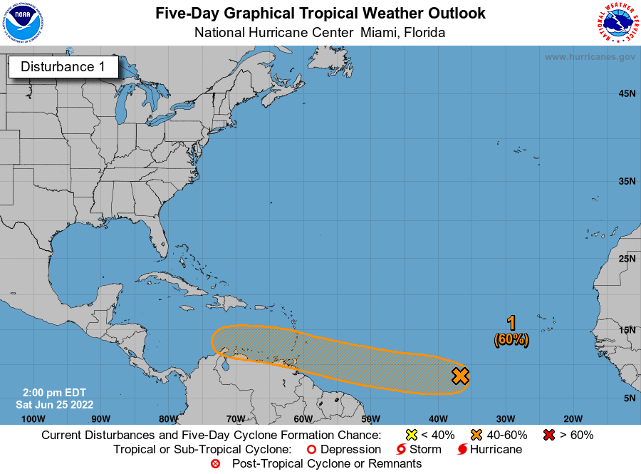
Active Atlantic Basin by Aidan Cera  The National Hurricane center is currently monitoring several disturbances out in the Atlantic this afternoon and have been for the last few days. The area with the most interest as of late has been Potential Tropical Cyclone 02L. Invest 95L is also churning in the Gulf of Mexico and has a 40% chance of developing in the next 2-5 days respectively. There is also a tropical wave located in the central Atlantic that may try to get going in the coming days but odds of this are only slight at this time.  Potential Tropical Cyclone 02L PTC 02L continues to struggle this evening under the influence of easterly shear and strong surface trade winds. Convection has also waned the last few hours as we approach the diurnal minimum. However, a surface circulation is evident on satellite imagery and based on surface observations out of Venezuela, therefore this is likely a tropical storm, but the NHC will likely not classify it as such until we see more persiste

Atlantic waking up?

Image
 Tropical Update 06/25/2022 Invest 94L by Aidan Cera The National Hurricane Center is currently monitoring Invest 94L, a tropical disturbance in the central Atlantic. This tropical wave has been tracked for several days now, and model consensus is that a tropical cyclone will likely come out of this wave at some point or another. When and where are heavily dependent on small scale and convective factors in the short term. There is a 30% chance of this wave developing a tropical cyclone in the next 2 days and a 60% in the next 5 days.  Currently, there is no convection associated with 94L and the disturbance is in bad shape. Dry, stable air and possibly cooler sea surface temperatures are putting a lid on thunderstorm development. Ironically though, a weak low level center is evident on satellite indicating that all this system needs is some consistent thunderstorm activity to be classified as a tropical cyclone.  One benefit of this convective demise is that it could allow the surface

SE Wisconsin 06/14/22 Weather

Image
Wednesday SE Wisconsin Weather Excessive Heat Wednesday, with severe storms arriving Wednesday evening by Aidan Cera   The Heat Today has been extremely hot and humid across most of southeastern Wisconsin with lakeshore areas from Port Washington to north of Sheboygan being the exception due to a lake breeze out of the southeast.  A heat advisory is currently in affect for all of southeastern Wisconsin until 8pm on Wednesday, due to heat indexes peaking near 100F. Sufficient to say the miserable heat is expected to stick around going through tomorrow as southerly flow from the Gulf of Mexico advects moisture and heat northward. Even the lake shore communities will likely be in the 80s tomorrow to low 90s assuming the lake breeze does not kick in as it did today. Highs across most of southeast Wisconsin will be in the low to mid 90s, with heat index values near or possibly exceeding 100F. Dew points will remain in the low to mid 70s as well, so it will feel quite soupy.  Severe Storms P