July 28th Central Minnesota Weather Discussion
July 28th Central Minnesota Weather Discussion
By Aidan Cera
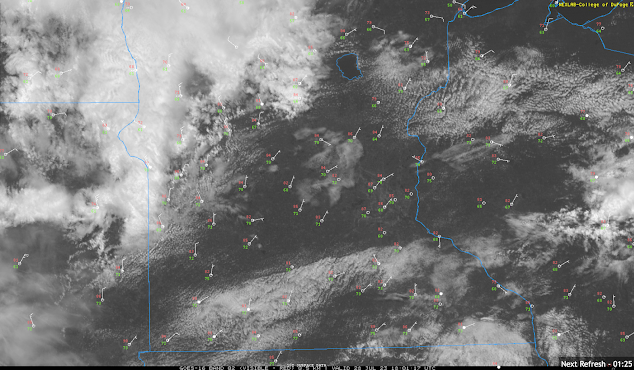
We do have some shower activity making its way into Minnesota from South Dakota currently and moving into Todd and Morrison counties as of around 1 PM CST. These showers are not really expected to produce much in terms of rainfall given their light and brief nature, so nothing to really dent the now extreme drought across much of the area, but a welcoming rain nonetheless, especially for the folks who saw hardly any rain yesterday or the days before. Given the difference between the temperature and the dew point there will likely be some evaporation of the rain before it hits the ground, especially in the northern central Minnesota counties such as Todd, Morrison and Crow Wing where the dew point depression it greatest, but counties such as Douglas, Pope, Stearns, Meeker, Benton and Sherburne counties have less of the dry air factor so more rain may fall there depending on what the rain band does over the next hour or two.
Fig 2. College of DuPage live radar feed for Minnesota as of 1:20 PM CST July 28th, 2023.
As rain that does fall today will be on the brief side so nothing to cancel any afternoon plans over. Thinking the showers reach Pope and Douglas counties around 1:45-2:00 PM, reach the St Cloud metro by around 3PM and exit the central Minnesota region likely by 4:30 PM or so.
Highs today are likely already reached across most of central Minnesota thanks to the incoming rain and increasing cloud cover, so not expecting much in terms of climbing temperatures. Dew points are likely already at their peak as well so not to concerned about any additional rises. Once the rain clears out there still should be some residual cloud cover keeping temps from warming too much.
Heading into tonight, looking at low temperatures in the low 60Fs to upper 50Fs across much of the area which will make for a much cooler night than we have seen most of the past week. Any showers or thunderstorms still around the area should be out of here by late evening.
Saturday looks much nicer with highs in the low to mid 80Fs across central Minnesota with lower dew points as well thanks to the passage of a cold front later today and tonight. Skies will also be mostly sunny thanks to high pressure rolling in from the NW. Sunday looks to be pretty much the same with regards to temperatures and sunshine, so no real difference between the forecast on Saturday and the forecast on Sunday.
Heading into next week things become slightly more murkier with regards to precipitation chances returning. A lot is going to ride on the 500mb heights and where the trough and ridging positions will be over North America. It seems we will see a pronounced return of eastern Canadian troughing which we have seen plenty of this summer. However, the troughing does seem to be centered slightly further east than in past troughing events in eastern Canada, so this will likely allow the ridge to our west nudge a bit more north and eastward heading into early next week. Assuming this happens, we can expect steadily climbing temperatures through the beginning of next week. By the middle of next week, the 90Fs will likely return to the area.
Now in terms of precipitation, the type of pattern we will be going into suggests propagating shortwave activity along the northern and eastern periphery of the ridge associated with the deeper trough out east. These short waves will likely be on the weaker side and will provide very little forcing for any convection to blow up across the area. There may be enough forcing though to fire off a couple of your popcorn variety showers and thunderstorms each day next week, but it will no means be anything widespread.
Given this, other than today, the forecast period looks mainly dry and on the warmer side, especially going into the middle of next week. No real severe weather threats are expected during the forecast period other than a an escalation in the significant drought we are experiencing.
That's all that I have today for central Minnesota weather. Will likely post additional updates tomorrow or Sunday with regards to the heat return potential next week and any precipitation chance signals in the modeling that may be more eye catching than it is now. Enjoy your Friday central Minnesota!!!


Comments
Post a Comment