July 27th Central Minnesota Severe Weather Discussion
July 27th Central MN Severe Weather Discussion
By Aidan Cera


Fig 1. Storm Prediction Center severe weather outlook for Thursday, July 27th 2023 issued at 1612Z (Zulu time).
Today has the potential to be a significant weather day across central Minnesota. The Storm Prediction Center has issued a Enhanced Risk of severe weather for potions of northern Minnesota and northern Wisconsin and a Slight Risk for a good chunk of eastern and central Minnesota and northern and central Wisconsin for today. While the types of severe weather expected varies from region to region, this discussion will primarily focus on the threats across central Minnesota.

Fig 2. Weather Prediction Center Surface Analysis Issued July 27th 1500Z.
Looking at surface analysis, there is a warm front draped across central Minnesota responsible for the advection of very warm and moist air into our area. Temperatures are mostly in the upper 80Fs to lower 90Fs across central Minnesota with dew points at a miserable level of low to mid 70Fs, making it feel like Brazil out there. These high dew points and high temperatures are essentially going to act as rocket fuel for any thunderstorms that develop across the area today as forcing from the warm front currently stationed over southern Morrison and Todd counties lingers overhead and a low pressure and associated cold front track through later today.
I am going to be discussing some more in depth details about today's severe weather threat, so those of you who want to read into more technical things feel free to, if you want to skip to the end where I summarize the moral of the story feel free to do so as well :)
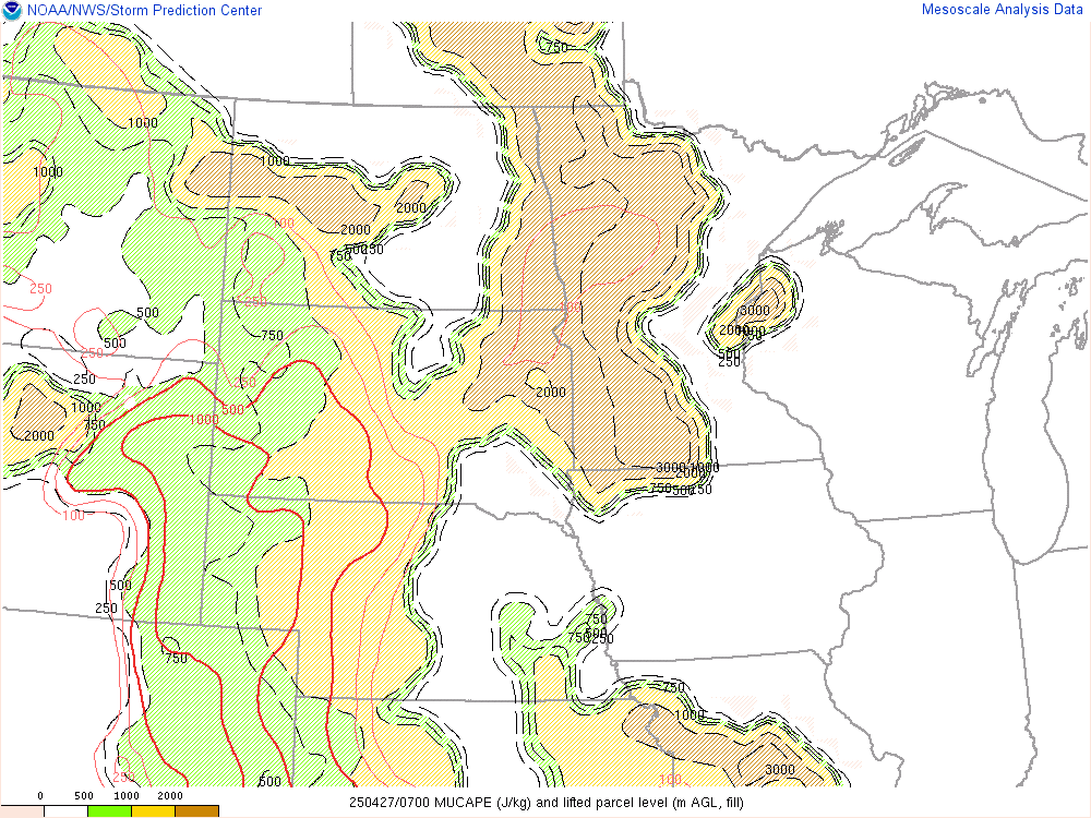
Fig 3. Storm Prediction Center Mesoanalysis with Convective Available Potential Energy and Lifted Parcel Level Height as of 1700Z.
Looking at our most unstable CAPE fields, we are entering some truly remarkable territory. Convective Available Potential Energy (CAPE) levels are through the roof, with values between 4,000 J/kg to 5,000 J/kg across central Minnesota. For brief explanation, CAPE is essentially the amount of energy available for rising air to use to continue rising/accelerate and feed thunderstorm development. The more CAPE you have the more energy is there for thunderstorms to blossom. Given that we have these high CAPE values overhead, any storms that do form are going to do so very quickly and likely violently.
Lapse rates in the lower levels are around 7 C/km and between 7C/km and 8C/km in the mid levels. This is the rate at which air cools as you ascend higher into the atmosphere. If air is allowed to rise and reached condensation level quite quickly, these steep lapse rates will only encourage the rapid growth of thunderstorms heading into this afternoon and evening.
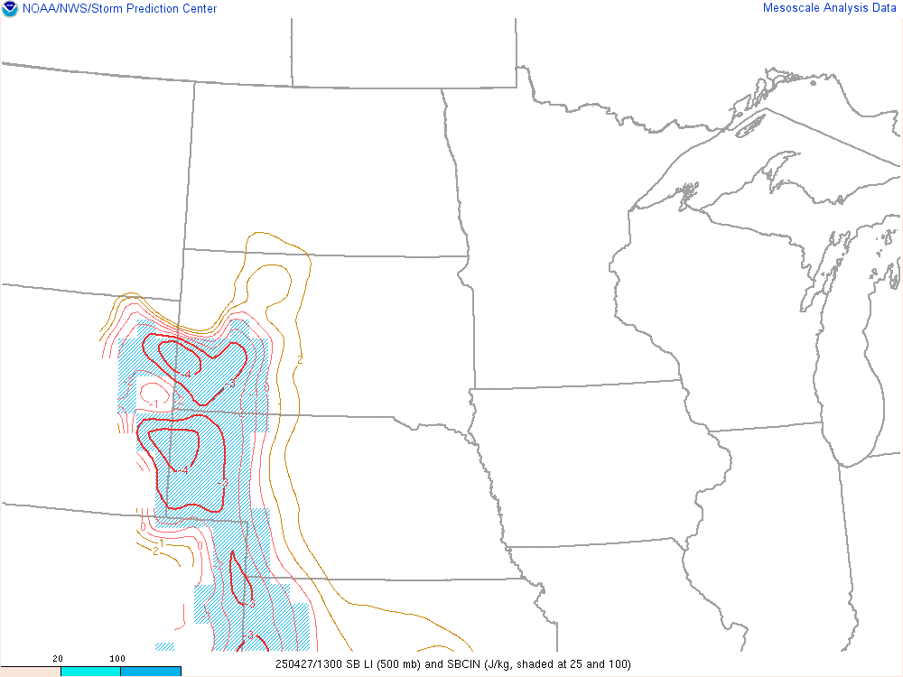
Fig 4. Storm Prediction Center Mesoanalysis Surface Based Lift and Surface Based Convective Inhibition as of 1700Z.
Our surface Lift is also quite low, with values between -8 to -10 across central Minnesota. Lift is the amount of buoyancy the air has or it's ability to rise, so this really tells us what other environmental conditions already do: the air is primed for thunderstorm development (due to rising air).

Fig 5. Storm Prediction Center Mesoanalysis Effective Bulk Shear as of 1700Z.
Once these thunderstorms get going, there is a decent amount of shear as you ascend. This will allow for tilt of updrafts and downdrafts allowing for their separation. Thus, we can expect storms to be more long lived and have a higher likelihood at becoming severe.
Given that most models agree that initiation of thunderstorms could occur over central Minnesota, we will be dealing with the earlier stages of these storms. This means that the primary threat is going to be more so significant hail due to mid level dry air indicated in recent HRRR model run soundings.

Note the mid level dry air circled as well as the distance between the purple line (parcel path) and red line (environmental temperature). The difference between the red and purple line is your CAPE. This CAPE profile suggests very strong updrafts and thus equally strong downdrafts since these updrafts will lead to higher storm heights and more room for acceleration of cooling air downward as well. Add the dry mid levels to the scheme and this yields a large hail threat.

Fig 7. Storm Prediction Mesoanalysis for Large Hail Parameter as of 1700Z.
Mesoanalysis shows a significant large hail parameter space across a decent chunk of central and eastern Minnesota. This gives more credibility overall that a large hail threat is certainly something to be concerned with.
Currently satellite shows some cumulus clouds making their way through central Minnesota with capping seeming to be the main reason these clouds have not blown up yet. Will likely have to wait till later this afternoon when the cold front gets closer to break through that CAPE and have thunderstorms develop. There is a lot of uncertainty on where these storms fire, when, and how long they continue to fire into tonight. Some mesoscale models indicated training thunderstorms across central and eastern Minnesota, specifically starting in Stearns County and making their way eastward into western Wisconsin through later tonight, but again, this is going to come down to where the cold front will be and pre existing thunderstorm activity.
To summarize: A severe thunderstorm threat is there across central Minnesota today. All severe threats are possible but the main threat at this time appears to be significant hail. If you are able to park your vehicle somewhere to avoid hail damage when storms arrive it is strongly advised that you do so in the event of large hail. This large hail threat should decrease some going into the evening and overnight hours, but storms could still be around and training over certain areas, that is, continuing to track through the same area over and over again, so we could be dealing with inclimate weather for the next 12 hrs or so, perhaps even later into the night depending on the cold fronts position.
It will be very important to keep an eye on local forecasts, the sky and radar today for any of these storms that do pop up. It is also important to check the forecast frequently, as these storms will likely pop up very quickly with minimal warning. Watch for the growing puffy clouds and dark skies on the horizon especially to the west. If outside, excessive heat is going to be an issue so drink plenty of water and keep cool to avoid getting heat exhaustion and heat stroke. I've had both and believe me, they are NOT fun. Stay safe out there today central Minnesota and stay sky aware!
Today: Severe thunderstorms possible. Highs in the low 90Fs with dew points in the mid 70Fs. Large hail is the primary threat with gusty winds and a tornado or two possible as well. Storms more likely between 2PM to 12AM tonight.
Tonight: Scattered strong thunderstorms possible, with large hail being the primary threat. Most likely timing for storms seems to be till around 12AM.


Comments
Post a Comment