Details on Tomorrow's Storm
Details on the Tuesday-Wednesday Storm
by Aidan Cera
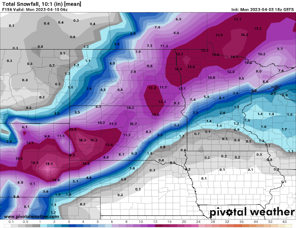
Figure 1. GEFS Ensemble mean snowfall forecast through Wednesday afternoon.
Details have become more clear with regards to the system expected to impact the upper Midwest Tuesday through Wednesday afternoon. Everything from blizzard like conditions to the conditional threat for severe thunderstorms are expected dependent upon location of course.
Figure 2. GFS 850 hPa temperature, temperature advection, frontogenesis and wind. Red contours represent temps above freezing, blue contours represent temps below freezing. Red shading represents warm air advection, blue shading represents cold air advection. Purple contours represent frontogenesis. Wind barbs are also plotted.
A warm front is expected to amplify as it tracks northward across Iowa and into Minnesota tomorrow morning through the afternoon. Associated warm air advection will lead to increasing temperature and dew points across the entire forecast region (Minnesota, Wisconsin, Iowa and northern Illinois.) This advection of moisture is expected to lead to a large shield of stratiform precipitation forming across northern and eastern Iowa, Minnesota and Wisconsin Tuesday afternoon. At the same time, a shield of snow along the northern side of the amplifying low is expected to begin working it's way out of South Dakota and into western and northwestern Minnesota Tuesday afternoon and will overspread this area through Wednesday afternoon. Regarding precipitation type for this event, northern and far western Minnesota is expected to receive mainly snow, central Minnesota is expected to see a rain/snow/sleet mix with more rain the further south you go, and mostly rain across Iowa, southeastern Minnesota and most of Wisconsin.
The strong warm advection taking place to the east as well as strong cold air advection advection wrapping beneath the low in tandem with an amplifying upper-level trough will lead to a deepening area of low pressure. The result of this process will lead to a very tight pressure gradient across the Dakotas and into Minnesota Tuesday afternoon through Wednesday. This will further result in very strong winds with gusts over 45 mph at times across most of Minnesota.
In northern Minnesota, strong winds along with the very heavy snow that is expected to track across the region has resulted in the issuing of Blizzard Warnings in parts of far western Minnesota and Winter Storm Warnings in northern Minnesota. Central Minnesota is under a Winter Weather Advisory due to some wintry precipitation mixing in with the rain early in the event and on again on Wednesday.
Figure 5. NWS warning and advisory graphic for Minnesota winter weather. Unlike the last system, less snow is expected to fall and accumulate across central and eastern Minnesota. Only a dusting is expected across the Twin Cities metro while 1 to 2 inches is expected from Hinckley, MN through St. Cloud, MN down toward Madison, MN. Areas closer to Alexandria, MN and Brainerd, MN may be looked at snow totals closer to 6" in some places.
Heading into Tuesday Night the cold front will pass through Minnesota, Iowa and Wisconsin bringing with it much colder temperature to the area.
Severe Storm Threat
Once again, eastern and central Iowa, northwestern Illinois and southern Wisconsin is under the gun for some potentially strong to severe thunderstorm activity Tuesday afternoon into Tuesday night. While there are some factors that may hold off thunderstorm development initial, scattered severe thunderstorms are expected to develop along a dry line across Missouri up into Iowa later Tuesday afternoon and move into Illinois and Wisconsin Tuesday night. All modes of severe weather will be possible including large hail, damaging winds, and strong/long track tornadoes.
As explained earlier, a warm front is expected to track across Iowa and Wisconsin Tuesday afternoon. Behind the warm front, ample warmth and moisture advection is expected to take place. Temperatures well into the 60s
are expected to work their way northward across eastern Iowa, northern Illinois and southern Wisconsin.
are expected to work their way northward across eastern Iowa, northern Illinois and southern Wisconsin.
Figure 10. GFS 2 meter air temperature in F for Tuesday Night long after warm frontal passage.
Dew points are also expected to reach well into the mid 60s across southern and eastern Iowa, northern Illinois and southern Wisconsin Tuesday afternoon into the overnight hours which is fairly uncommon for this time of year.
These warmer temperatures and higher dew points will for ample destabilization potential with CAPE values ranging potentially exceeding 2,000-3,000 J/kg. Most models reflect a similar idea to the GFS as shown below in Fig. 12. High CAPE will mean plenty of fuel for any storms that are able to initiate along the dry line and cold front Tuesday afternoon into the overnight hours.
While there appears that there will be plenty of CAPE available, higher dew points and warmer temperatures, there does remain some possibility that the gap between the dew points at the surface and temperature profiles may limit thunderstorm nature to be more elevated across Iowa, especially early on the initiation process. If this holds true, and we see capping as many of the models indicate, thunderstorm activity may be stunted and severe potential will be limited to large hail.
However, some models do not show as strong as a dew point depression and not as strong of a cap aloft, which could lead to more widespread thunderstorm development across central and eastern Iowa Tuesday afternoon.
Figure 13. ECMWF Sounding generated for southeastern Iowa Tuesday afternoon.
If there is limited capping and air is allowed to rise, then shear vectors appear extremely favorable for supercell development. Less of a cap would mean more widespread severe thunderstorm potential. More capping would mean less widespread severe weather potential, but regardless, any storms that do manage to get going in the environment models depict would have an easy time becoming supercellular in nature and could very well produce long track, strong tornadoes.
Tuesday night the cold front is expected to quickly catch up with the dry line. Additional forcing along the front will likely lead to another round of severe thunderstorms capable of all modes of severe weather across central and eastern Iowa, southern Wisconsin and northern Illinois. The greatest concern is the threat for a nocturnal tornado event. Environmental conditions are still expected to be very favorable for tornado producing supercells well after sunset across eastern Iowa, southern Wisconsin and northern Illinois given the high CAPE values and extremely favorable wind profiles at the surface and aloft. The low level jet will also aid in the amplification of a veering wind profile across this region which will only increase the risk for significant tornadoes overnight.
It is expected that these storms should take on a more linear mode overnight once the cold front catches up to the dry line, but even then, these cells could easily maintain a more semi-discrete mode making them all the more likely to continue producing long track tornadoes, large hail and damaging winds. It will be very important for northern Illinois, eastern Iowa and southern Wisconsin to remain weather aware long after the sun goes down due to this continued potential for nocturnal tornadoes with any semi-discrete supercells that are able to maintain themselves in this highly volatile environment.
In summary, another potent weather system is expected to bring all modes of weather to the upper Midwest tomorrow through Wednesday. It will once again be very important for interests in these areas to remain weather aware over the next 24-48 hrs. For the best forecast information and prior to any decision making please visit your local NWS offices website, the SPC's website, and the WPC's website.


Comments
Post a Comment