Posts

June 5th 2023 Central Minnesota Weather Outlook

Image
 June 5th 2023 Central Minnesota Forecast by Aidan Cera We have been stuck in a extremely stagnant weather pattern bringing hot and humid conditions across central Minnesota as of the last week or so with very little rain as most of the precipitation has fallen to the west and south. Really not expecting much change in terms of rain chances around here but today is the first of several where we will have coo ler temperatures than last week and the weekend.  Rest of Monday The semi-stationary front has moved across central Minnesota as indicated by radar and the drop in temperatures across the region. We are watching some developing thunderstorms across western Stearns county, Pope and Douglas counties to the west and Meeker county to the south. These storms are remaining relatively stationary while showers from northern Minnesota should decay as they track closer to our area. The main takeaway is that today is not turning out to be a washout out for everyone and most of centra...
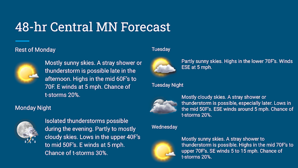
Monday - Wednesday Forecast 05/08/2023

Image
Central Minnesota Monday-Wednesday Forecast Update Issued 05/08/2023 3:23PM CST By Aidan Cera  A lot of rinse and repeat had been taking place as of late in terms of our weather and the next several days will be no different. Yesterday was a fantastic day; however, with all the of the storm activity missing us well to the south. Temperatures reached into the 70s and skies were mostly sunny a majority of the day. Today has been relatively similar thus far.  Rest of today into tonight Skies will remain mostly sunny through the rest of today. Temperatures are currently quite varying with temperatures in the lower 60s near Little Falls, MN, and temperatures nearing or just above 70F near Willmar, MN. Highs will top out near 70F for most of central Minnesota today thanks to ample sunshine. Winds will be WNW generally at 5 mph.   I am watching a boundary along the Minnesota/Wisconsin border and another potential boundary that will work it's way over us later this...

Saturday - Monday 05/06/23 Forecast

Image
 Central Minnesota Saturday - Monday Forecast Update Issued 05/06/2023 By Aidan Cera  Temperatures have taken a dip today due to the cloud cover over central Minnesota and even a few scattered showers that have tracked through from the south in association with a stationary front. Temperatures are currently sitting at 55F in St. Cloud, 51F in Alexandria, 59F in Wilmar, 52F in Little Falls, and 60F closer to the Twin Cities metro area.  Rest of Saturday/Saturday Night This afternoon and evening still look to have the best chances of showers and thunderstorms across central Minnesota, but I think the chances have decreased slightly from earlier today given recent radar trends.  I am currently seeing some shower and thunderstorm activity extending from Hudson, WI southeastward across Northfield, MN and down to Fairmount, MN. The area I am most focused on is southwestern MN from Canby, MN through Marshall, MN and into Worthington, MN. There are a few scattered showe...

05/04/2023 Central Minnesota Weather Forecast

Image
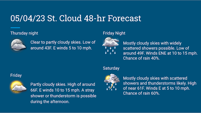
 A Look at the Weekend Ahead by Aidan Cera Posted Thursday 05/04/2023 Spring weather has finally arrived across central Minnesota! Highs today reached into the mid 70s across much of the region with plenty of sunshine and relatively light winds. We are currently sitting at a pleasant 66F as of around 9:30 PM CST in St Cloud, MN.  Trees are also starting to show signs of budding and it likely won't be long until leaves start popping up on the trees either. While this is a beautiful site to see after such a long and snowy winter, this unfortunately also means allergy levels are going to run rampant sooner rather than later. For any allergy sufferers out there, if you have over the counter medications you typically take during the spring and summer, now is likely the time to start taking them again.  Looking to the weekend ahead, we have a rather complicated forecasts on the table. Several small jet level disturbances are expected to propagate across the northern P...

Details on Tomorrow's Storm

Image
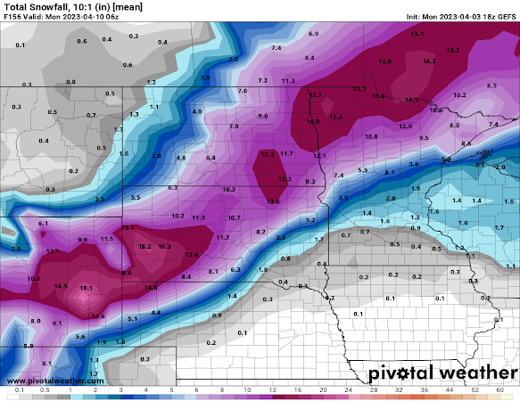
 Details on the Tuesday-Wednesday Storm by Aidan Cera Figure 1. GEFS Ensemble mean snowfall forecast through Wednesday afternoon. Details have become more clear with regards to the system expected to impact the upper Midwest Tuesday through Wednesday afternoon. Everything from blizzard like conditions to the conditional threat for severe thunderstorms are expected dependent upon location of course.  Figure 2. GFS 850 hPa temperature, temperature advection, frontogenesis and wind. Red contours represent temps above freezing, blue contours represent temps below freezing. Red shading represents warm air advection, blue shading represents cold air advection. Purple contours represent frontogenesis. Wind barbs are also plotted. A warm front is expected to amplify as it tracks northward across Iowa and into Minnesota tomorrow morning through the afternoon. Associated warm air advection will lead to increasing temperature and dew points across the entire forecast region (Minneso...

Another Potent System Incoming

Image
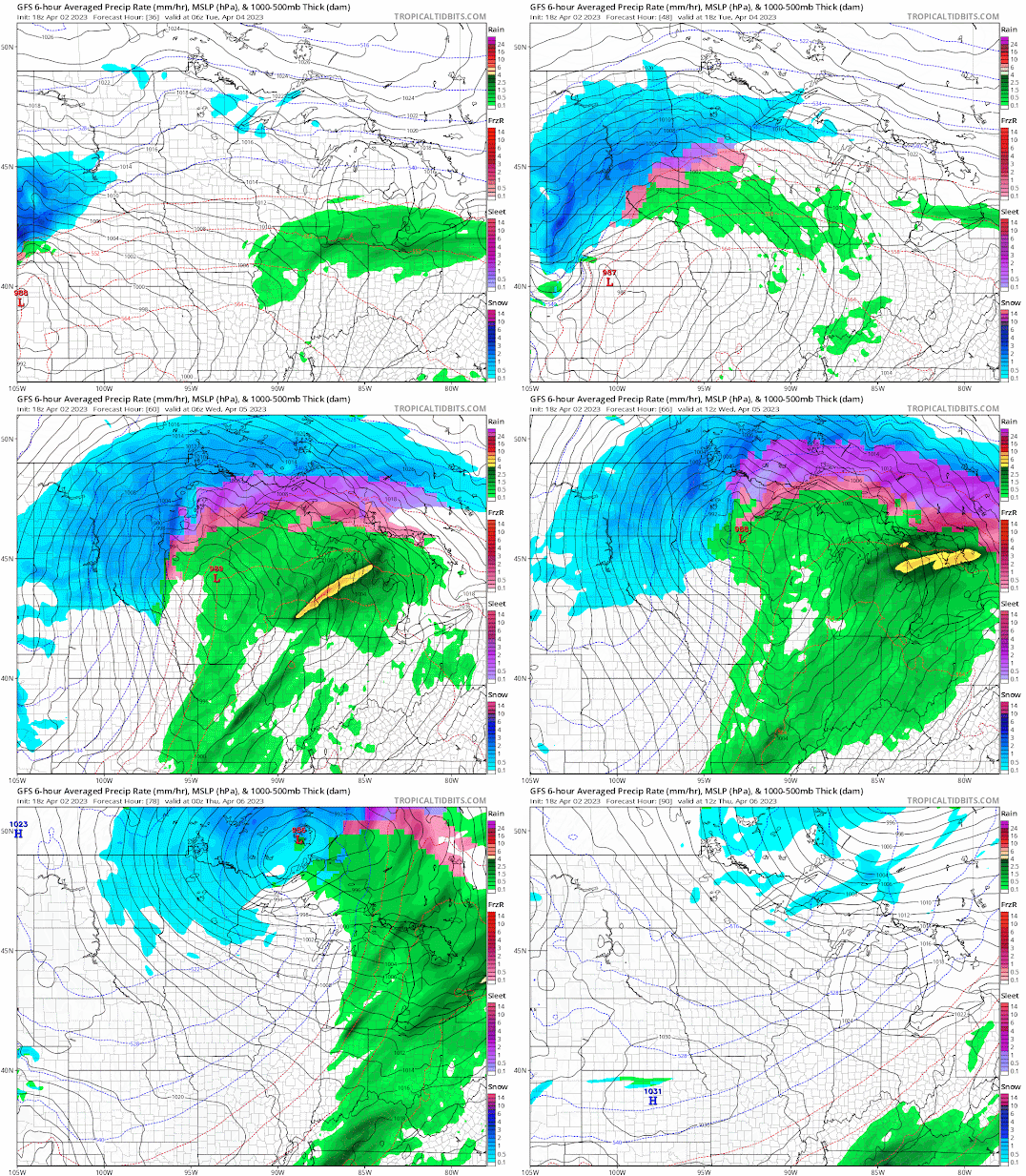
 Another Potent System Incoming this Week By Aidan Cera  Figure 1. GFS 18Z 04/02 output valid Monday night through Wednesday morning. We are finding ourselves facing another powerful storm system that is expected to track across the upper Midwest Monday through Wednesday Night. Like the system last Friday, this storm is expected to bring a little bit of everything to the Midwest from blizzard like conditions in Dakotas and northwestern Minnesota to a tornado potential down in Iowa. This is still considerable uncertainty in what exactly this storm will do so this discussion is going to focus more on the wide scale pattern and the general idea of what is expected to take place and where.  Upper-level Pattern Figure 2. EPS Ensemble 12Z 04/02 run Sunday through Thursday  A trough is expected to deepen as it traverses the Pacific Northwest and Rocky Mountain region Sunday night through Tuesday. The deepening trough is expected to lead to the development of a jet max ahead...

Potent Storm System to Impact Central US

Image
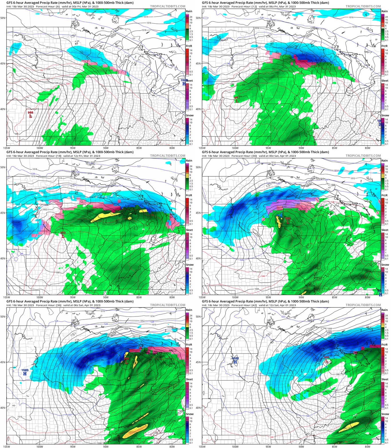
 Potent Storm to Impact the Central US tonight through Saturday  Aidan Cera  A powerful storm system is expected to track across the central United States beginning overnight tonight lasting through mid day on Saturday. All modes of weather are possible from blizzard like conditions to tornados across the upper Midwest tonight through Saturday morning.  Tonight             Figure 1. NAM-3km frontogenesis output initiated 00Z 03/31/23 through 12Z 03/31/23 Warm air advection is expected to advance northward overnight tonight across Iowa, Wisconsin and Minnesota along a warm front. This warm front will be the initial focus point for continued for a variety of precipitation across this region ranging from snow in Minnesota and northern Wisconsin to thunderstorms in southern Minnesota, Wisconsin and throughout Iowa.   Figure 2. HRRR-1km Res 00Z Reflectivity run spanning from 00Z to 12Z 03/31/23. As the warm front pushes no...