Monday - Wednesday Forecast 05/08/2023
Central Minnesota Monday-Wednesday Forecast Update
Issued 05/08/2023 3:23PM CST
By Aidan Cera
A lot of rinse and repeat had been taking place as of late in terms of our weather and the next several days will be no different. Yesterday was a fantastic day; however, with all the of the storm activity missing us well to the south. Temperatures reached into the 70s and skies were mostly sunny a majority of the day. Today has been relatively similar thus far.
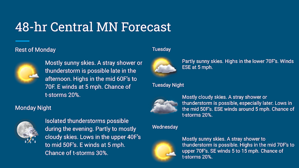
Rest of today into tonight
Skies will remain mostly sunny through the rest of today. Temperatures are currently quite varying with temperatures in the lower 60s near Little Falls, MN, and temperatures nearing or just above 70F near Willmar, MN. Highs will top out near 70F for most of central Minnesota today thanks to ample sunshine. Winds will be WNW generally at 5 mph.
I am watching a boundary along the Minnesota/Wisconsin border and another potential boundary that will work it's way over us later this evening and into the overnight hours. Either one of these boundaries may be a focus point for some weaker end shower and thunderstorm activity. An showers or storms that develop would be rather isolated in nature so am not expecting a widespread event. In fact, there is a good chance so activity happens at all due to weak forcing in our area due to thickening heights above us and low levels of instability as a result.
Regardless of isolated shower and thunderstorm development or the lack thereof this evening, skies will be on the increase throughout the night. Temperatures tonight could range quite a bit with upper 40s for lows near Little Falls, MN and back off toward Sauk Centre, MN while lows may only dip into the mid 50s for Willmar, MN and Hutchinson, MN. The lows will likely depend on how much cloud cover we see as more clouds will provide more insulation to prevent heat from escaping the lower atmosphere. Winds will be WNW around 5 mph but shifting in a more eastward direction overnight.
Tuesday/Tuesday Night
Tomorrow will be fairly similar to today in terms of low precipitation chances and temperatures, just slightly warmer and with more clouds.
The remnants of a MCS may drift over our area tomorrow heading into the afternoon hours which will provide more cloud cover but I still think we should see a fair deal of sun tomorrow. Highs will be nearing 70F and pushing into the low to mid 70s in some areas, depending on the amount of sun. Not really expecting anything in terms of precipitation tomorrow due to the lack of any forcing nearby. Winds will be generall ESE at around 5 mph.
Tuesday Night skies will once again become more cloud covered. A stray shower or thunderstorm may be possible later in the night but am not really expecting much due to a lack of an forcing or frontal boundary in the area. Lows are expected to drop into the mid 50s across most of central Minnesota. Winds will once again be ESE at around 5 mph.
Wednesday
As we head into the middle of the weak, a upper level trough is expected to begin tracking slowly eastward across the Rocky Mountain region. This trough will begin to introduce some weak forcing in our area on Wednesday. I think a slight chance of shower and thunderstorm activity is warranted but am by no means saying everyone will see rain. There is once again the possibility no one sees anything at all as well.
Temperatures are also expected to be warmer than Monday and Tuesday with expected highs ranging from lower to upper 70s. SE winds 5 to 15 mph will advect these warmer temperatures northward.
Overall, I am expecting a warming trend as we head toward the middle of the weak and a slight chance of showers and storms here and there but nothing to be too concerned over. Just keep an eye on radar for any spotty activity that does develop.


Comments
Post a Comment