05/04/2023 Central Minnesota Weather Forecast
A Look at the Weekend Ahead
by Aidan Cera
Posted Thursday 05/04/2023
Spring weather has finally arrived across central Minnesota! Highs today reached into the mid 70s across much of the region with plenty of sunshine and relatively light winds. We are currently sitting at a pleasant 66F as of around 9:30 PM CST in St Cloud, MN.
Trees are also starting to show signs of budding and it likely won't be long until leaves start popping up on the trees either. While this is a beautiful site to see after such a long and snowy winter, this unfortunately also means allergy levels are going to run rampant sooner rather than later. For any allergy sufferers out there, if you have over the counter medications you typically take during the spring and summer, now is likely the time to start taking them again.
Looking to the weekend ahead, we have a rather complicated forecasts on the table. Several small jet level disturbances are expected to propagate across the northern Plains over the next few days making the forecast for central Minnesota rather uncertain but we are starting to get a general idea of what may pan out. Multiple chances of rain appear possible as these small disturbances track through, but I am not expecting a complete washout this weekend by any means.
Thursday Night
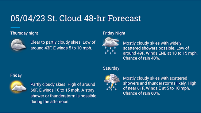
Starting tonight, we will see moisture transport increase as a stationary front pushes northward into southern Minnesota. Skies are generally clear currently but some energy associated with the stationary front will work its way northward and will likely cause some increase in the cloud cover later tonight.
Temperatures will cool tonight quite a bit due to relatively clear skies early on, with lows dropping into the lower 40s across most of central Minnesota. Dew points will likely be in the upper 30s so the air will still overall be rather dry.
Friday-Friday Night
We will start out the day Friday with quite a bit of sun which will allow temperatures to warm into the 60s by the early afternoon. Clouds will start to increase as the day progresses; however, due to the stationary front to our south. This front will serve as a focus point for scattered shower and thunderstorm development across southern Minnesota during the day on Friday. This will be primarily responsible for our increase in cloud cover, which will not allow our temps to climb as high as they did today. Also some rain cooled air may enter the area during the afternoon which could keep temperatures in the lower 60s especially the further south you go.
I do not think we will see much in the way of precipitation tomorrow afternoon. It appears that most of the precipitation will remain to our south; however, I cannot rule out a stray shower or thunderstorm making its way into central Minnesota especially later in the afternoon south of I-94.
Tomorrow night our forecast becomes a little less certain. Models are struggling to agree on how far north the stationary front will propagate, some models show the stationary front parked right over central Minnesota and some show the front remaining in southern Minnesota. The positioning of the stationary front will make the difference between lows in the mid 40s tomorrow night across central Minnesota and mostly dry conditions if the stationary front remains further south or lows in the low-mid 50s with precipitation chances if the stationary front tracks further north. Currently I see more agreement on the further south solution than the northern solution so am more inclined to lean toward the southern solution. However, I am choosing not to write the precipitation chances off entirely, so will include a chance of rain showers and perhaps a rumble of thunder or two in the forecast.
Saturday-Saturday Night
Saturday looks to be a cooler and more cloud covered day, with highs reaching into the lower 60s regardless of where the stationary front sets up Friday night.
An area of low pressure associated with an upper level weak shortwave trough is expected to advect northeastward out of Nebraska and across South Dakota into western Minnesota Saturday through early Sunday morning. This low will serve as another focus point for shower and thunderstorm development as we head into Saturday afternoon and especially into the evening. While it is not yet entirely clear where the main focus point of precipitation will be, I think all of central Minnesota has a fair chance at seeing more widespread shower and thunderstorm activity Saturday evening into Saturday night.
Sunday
Looks like we will keep a bit of cloud cover across central Minnesota going into Sunday as the low pressure tracks across northern Minnesota. Some shower chances will exist especially earlier in the morning, but I am expecting precipitation chances to back off for a little while later in the morning. As we head into Sunday afternoon however, shower and thunderstorm chances increase again due to some destabilization caused by clearing of the clouds and sunshine working through. Dew points will likely be above 50F with temperatures in the 70s which means any thunderstorm activity will likely be elevated during the afternoon. CAPE values may climb a little higher than on Saturday night thanks to any sunshine that takes place, and shear vectors look slightly more favorable for the possibility of some severe weather, especially across southern Minnesota. While I do not feel confident enough to explicitly forecast severe weather for central Minnesota Sunday afternoon into Sunday Night, I will mention the chances for continued scattered thunderstorm activity, a forecast generally in line with the NWS Twin Cities office.
I will be providing more information on this weekend over the coming days, now that I am done with school I will have far more time to invest into this blog :) Have a fantastic Friday everyone!


Comments
Post a Comment