Posts

Peak of the 2022 Atlantic Hurricane Season?
Image
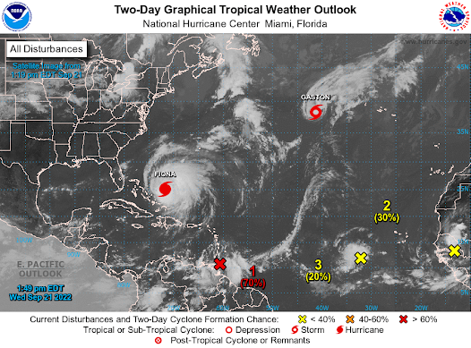
 2022 Atlantic Hurricane Season Update by Aidan Cera  09/21/2022 Figure 1. National Hurricane Center 2-Day Graphical Weather outlook for 09/21/22 2PM EST. The peak of the 2022 Atlantic hurricane season has arrived, albeit a little later than usual or expected. The NHC is currently watching 5 areas of concern, Major Hurricane Fiona, Tropical Storm Gaston, Invest 98L, Invest 99L and another tropical wave about to exit the coast of Africa. We'll look at each at system one by one below. Major Hurricane Fiona (07L) Fiona continues to track away from the Turks and Caicos and is holding intensity as powerful category 4 hurricane with 130 mph sustained winds and a central pressure of 937 millibars. The convective structure has begun to degrade with the eye beginning to cloud up and convection beginning to wain. The most likely reason for this is an eye wall replacement cycle. Given this possibility, it may be a while before we see a pronounced eye return, and intensity will likely beg...

Calm Week Ahead for Central MN

 Calm Week Ahead by Aidan Cera  A relatively calm week lies ahead for central Minnesota. After repeated rounds of severe weather this weekend curtesy of a negatively tilted shortwave trough. This trough has since moved eastward allowing for high pressure to build across the northern Plains that will last through most of this week.  Tuesday-Wednesday Sunny skies and highs nearing 80F are on tap for this Tuesday across central Minnesota. Winds will be relatively breezy out of the WNW at 10 to 15 mph. Tonight skies will remain clear with temperatures dropping into the low 60s or upper 50s. Skies remain clear Wednesday with slightly warmer temps in the low 80s for highs and a light westerly breeze. Wednesday will have clear skies and lows in the low 60s. Thursday-Friday Thursday looks dry across central Minnesota with plenty of sun. A shortwave trough will begin to push past to our north Thursday night. This trough will be well to our north so am not expecting but influence i...

Weather Outlook 08/22-24

Image
  Weather Outlook for 08/23-08/27 By Aidan Cera  Fig 1. Weather Prediction Center surface chart 0000Z 08/23 Tuesday Tuesday is going to be a near repeat of Monday, except slightly warmer with highs in the lower 80s across central Minnesota. Skies will be mostly sunny as high pressure continues to maintain control over our weather in the short term. As we head into Tuesday night, we will begin to feel the influence of a shortwave trough tracking southeast out of Canada. There does appear to be some vorticity advection associated with the first of a pair of weak shortwave troughs tracking from the northwest, so going to put a chance of light showers or perhaps a thunderstorm in for later on Tuesday Night.  Wednesday Wednesday we will see the first weak shortwave track eastward. Another shortwave will be making its way down from Canada later in the day Wednesday but a decent part of the day will be dry. In fact, many locations might stay entirely dry since the shortwave isn'...
Image
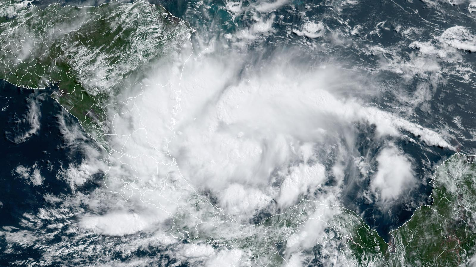
  2022 Atlantic Hurricane Season Outlook  August 3rd, 2022 By Aidan Cera  Fig 1. Tropical Storm Bonnie intensifying over the southwestern Caribbean Sea We are fast approaching the climatological peak of the Atlantic hurricane season. With the typical ramp up of activity only a week or two away, our attention is focusing on the Atlantic. This outlook takes into account current and past conditions across the Atlantic basin since the beginning of the 2022 Atlantic Hurricane Season, ranging from sea surface temperature anomalies to mid level atmospheric dynamics. Below is my quantitative rough estimate of how many named storms, hurricanes and major hurricanes we could see for the season as a whole. Named Storms —------------------------------ 14-18 Hurricanes —-------------------------------- 7-9 Major Hurricanes —-------------------------- 3-5 ACE —--------------------------------------- 120-150 ACE = Accumulated Cyclone Energy  Three named storms have already formed, A...

End of the Week Forecast

Image
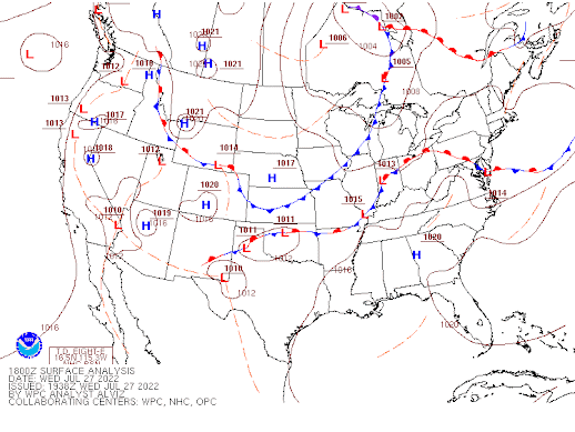
 Looking to the end of the week by Aidan Cera  Rest of Wednesday  After a few morning showers and thunderstorms, southeast Wisconsin has dried out, with some fluffy cumulus clouds passing overhead.  Looking at a surface analysis map from earlier this afternoon, we can see that there is a cold front draped across southeastern Wisconsin. This cold front is expected to continue eastward through the remainder of today and into tonight, with northwesterly flow behind it. This northwest flow is advecting cooler and drier air yet there is still some forcing and moisture left in the air behind the front. As a positively tilted shortwave trough propagates southward, some shower and perhaps a few thunderstorms may develop across western Wisconsin and track eastward into southeastern Wisconsin later tonight.  These showers/storms will be rather hit or miss and not everybody is going to see precipitation tonight. None of these storms are expected to be severe...

Severe Weather Possible Saturday (07/23)

Image
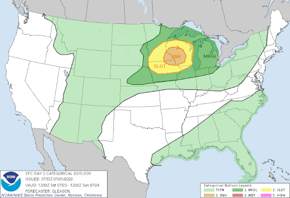
 Severe Thunderstorms This Weekend  by Aidan Cera  I have been keeping a close eye on Saturday across central and eastern Wisconsin with regards to the possibility of severe weather. The Storm Prediction Center has been highlighting this possibility for the last 2 days, below are the graphics issues by the SPC. The SPC has issues an enhanced risk of severe weather for southeastern Minnesota, northeastern Iowa and central Wisconsin for 07/23.  A "Sig" or significant risk for severe weather has been issues by the SPC for a decent chunk of Minnesota, northern Iowa and most of Wisconsin.  Synopsis A negatively tilted shortwave trough accompanied by a jet streak will advect out of the northern Great Plains and into southern Canada and into Minnesota Saturday afternoon then Wisconsin Saturday night.  The key take away from looking at the 250 mb level of the atmosphere is that there will be ample upper level divergence over Wisconsin Saturday afternoon into the ev...

Busy week in the tropics

Image
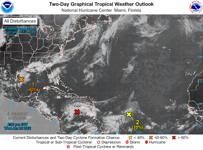
Active Atlantic Basin by Aidan Cera  The National Hurricane center is currently monitoring several disturbances out in the Atlantic this afternoon and have been for the last few days. The area with the most interest as of late has been Potential Tropical Cyclone 02L. Invest 95L is also churning in the Gulf of Mexico and has a 40% chance of developing in the next 2-5 days respectively. There is also a tropical wave located in the central Atlantic that may try to get going in the coming days but odds of this are only slight at this time.  Potential Tropical Cyclone 02L PTC 02L continues to struggle this evening under the influence of easterly shear and strong surface trade winds. Convection has also waned the last few hours as we approach the diurnal minimum. However, a surface circulation is evident on satellite imagery and based on surface observations out of Venezuela, therefore this is likely a tropical storm, but the NHC will likely not classify it as such until we see more...