End of the Week Forecast
Looking to the end of the week
by Aidan Cera
Rest of Wednesday
After a few morning showers and thunderstorms, southeast Wisconsin has dried out, with some fluffy cumulus clouds passing overhead.
These showers/storms will be rather hit or miss and not everybody is going to see precipitation tonight. None of these storms are expected to be severe.
Thursday
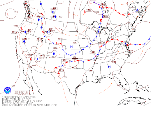
Tomorrow we will still be under the influence of the shortwave trough propagating around the larger trough in Canada. While upper level winds are expected to be strong aloft, these winds will no longer support surface convergence due to their zonal nature. Therefore there is a very low chance for precipitation tomorrow on the backside of the low pressure drifting to our East. Skies should remain at least partly sunny through most of the day, we'll likely see more clearing during the morning before diurnal heating leads to the development of some cumulus clouds similar to what we saw today once the morning storms exited the area.
Cooler Canadian air will be advected into southeastern Wisconsin on Thursday leading to noticeable northwest breeze of around 10 to 15 mph at times and cooler air temps in the upper 70s for highs. Dewpoints will also be on the drier side thanks to the cold front currently passing through and the northwest flow. A pleasant day overall!
Thursday Night looks dry with clearing skies and temperatures dipping into the mid 50s under the clear skies. Winds should diminish during the evening hours as we loose daytime heating.
Friday
Friday looks to be fairly similar to Thursday. We will still be under the influence of the back end of the low pressure to our east, so we will continue to see northwest flow at the surface, so cooler and drier air overall. Highs look to be in the mid to upper 70s for most of southeastern Wisconsin through the day with plenty of sunshine but with some fair weather cumulus clouds developing during the afternoon.
Overall, mostly dry and more pleasant next couple of days ahead for the Milwaukee metro and surrounding areas of southeastern Wisconsin. Enjoy!!!

Comments
Post a Comment