Rain For A Day Then Sun For A Day On Repeat
Central Minnesota Weather Discussion 04/30/24
by Aidan Cera
Rain Rolls Through Tonight
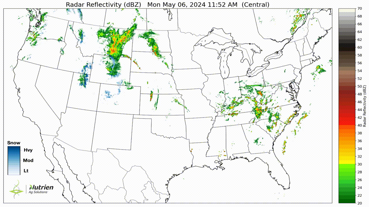
Good evening central Minnesota! Hope you are having success at dodging those drops that are coming down at quite a clip at times. This rain is part of a extensive band of showers and thunderstorms stretching nearly from Canada all the way down to Mexico! These showers and storms will continue to make their way eastward through the evening as a negatively tilted shortwave trough moves east as well. Thinking there will be a seperate broken line of storms that will develop behind this first round of rain given remaining instability and moisture but not everyone will see this rain.

Skies should clear out as the night progresses, with lows falling into the mid 40ºF's for most of central Minnesota.
Case of the Deja Vu's
As alluded to in the title, we are going to see a lot of on again off again precipitation events, with a say of sun and warmth in the middle. Wednesday is going to be absolutely beautiful, with highs in the upper 50ºF's for our northern counties, highs approaching 70ºF down near Granite Falls and highs in the mid 60ºF's in between (St. Cloud, Alexandria, Monticello etc.). Skies will be mostly sunny as weak high pressure passes through.
Clouds will be on the increase Wednesday night as our next weather system approaches from the southwest. Lows will dip in to the mid to upper 40ºF's across the entire region, with cloud covering keeping those temps quite uniform.
Thursday morning more rain arrives as a low pressure center passes to our south and the northern periphery of the precipitation shield swipes across the region. Not expecting any prolific rainfall totals from this system, but our southern and central counties can expect up to half an inch of precipitation while northern counties can expect up to a quarter of an inch through Thursday Night. Highs will be around 60ºF across most of the region given the widespread cloud cover and rain showers.

Thursday Night through the weekend we are going to be under the influence of a weakening low pressure to our northwest that is going to slowly slide east. I still think we may see some sun on Friday despite proximity to the low, which should allow temperatures to climb to at least 60ºF for our northern counties and into the mid 60ºF's for our southern counties. Cass, Todd and Crow Wing counties do have a small chance at seeing some rain Friday due to being closer to the low, but this will by no means be a wash.
Another wave of energy will ride the southern periphery of the low's influence going into Saturday, with more rain possible during the morning and early afternoon before high pressure begins building in from the west and the dying low to our north is finally pushed eastward. Again, no prolific rainfall totals are expected for anyone, with higher totals the further south you go. The coverage of this rain is still a little uncertain, but chances will increase the further south and east you are. Temperatures will be held back a bit on Saturday due to the rain and cloud cover, but should not have issues reaching 60ºF for our northern counties and reaching into the upper 60ºF's in our far southwestern counties. Central counties will be somewhere in the middle (low to mid 60ºF's).
A Different Pattern? No Just Kidding
Sunday looks more quiet as a more prominent high pressure system is forecast to slide eastward. Temperatures could easily climb to 70ºF across all of central Minnesota based on the amount of sunshine expected. Northern counties could be around or just below 70ºF, with our central counties being in the low 70ºF's, and our southern counties being in the mid 70ºF's.
By Monday, once again, we will start to feel the influence of yet another storm system gradually shifting east across the Rockies and into the Plains. Warm air and moisture transport ahead of the incoming low should push highs above 70ºF across all of central Minnesota and into the low 70ºF's for our northern and central counties, with mid 70ºF's for our southern counties. Forcing from an approaching negatively tilted shortwave trough should begin overspreading Minnesota by Monday afternoon, but at such long ranges it is hard to say if this will indeed be the case. For now, kept a chance of showers and thunderstorms for the afternoon for all of central Minnesota.
Storm chances increase for everyone Monday night into early Tuesday morning. Forcing is certainly expected to be present by this time, with an area of low pressure sliding through to the northwest and accompanying cold front bulging eastward. While this system is still a ways out, I honestly do think this will be central Minnesota's first shot at seeing widespread thunderstorms given the atmospheric profiles projected at this time. Storm chances will continue into Tuesday night but I don't have enough confidence to go into too much detail about this system at this time, just something to watch for the time being.
That about sums up what the weather is going to look like around here the next week or so. Stay tuned for further updates! I graduate this week so my schedule gets a little more hectic toward the end of the week but I will certainly do my best to keep the updates coming. Have a great night everyone!


Comments
Post a Comment