August 16th Central Minnesota Weather Discussion
August 16th Central Minnesota Weather Discussion
By Aidan Cera


Fig 1. Storm Prediction Center Convective Outlook for August 16th 2023 Issued at 1609Z.
Good afternoon central Minnesota! Figured I would do a brief discussion on the possibility of severe weather across the region later this afternoon into the evening hours.
The Storm Prediction Center (SPC), has issued a slight risk for severe weather for the central and eastern portion of central Minnesota. All severe modes are possible, including damaging winds (15%), large hail (15%) and tornadoes (2%).
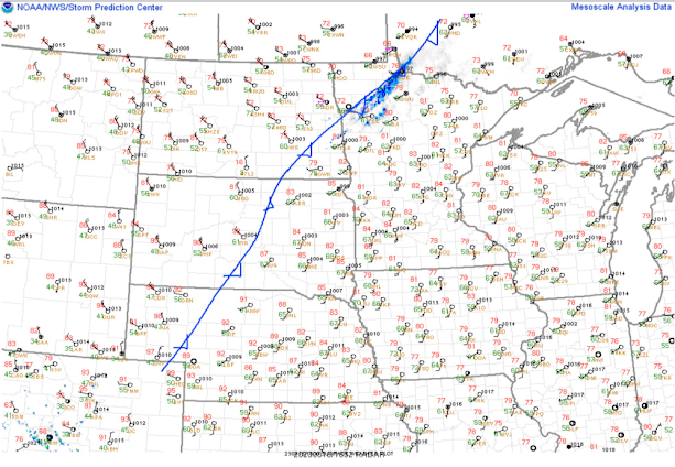
Fig 2. SPC surface analysis as of 1900Z (2:00 PM CDT). Red numbers indicate temperature and green values represent dew points in degrees Fahrenheit. Wind barbs show wind direction.
As of around 2 PM CDT, a cold front was located in northwestern Minnesota and into southeastern North Dakota based on surface wind obs and pressure tendencies. This cold front is quickly advecting southeastward as the afternoon progresses and should arrive in central Minnesota by 4-6 PM CDT.
Currently, temperatures are in the upper 70F's to mid 80F's across central Minnesota with dew points in the low to mid 60F's generally. Based on satellite imagery, these regions have not reached the required temperature to kick off any convective processes as of yet. It also does not help that there was a strong low level cap or thermal inversion recorded on the 1200 UTC/Z sounding taken at the MSP/Twin Cities NWS this morning. This capping along with the rather wide gap between temperature and dew point values is likely why little in terms of cloud activity is happening yet. High clouds associated with the front are quickly streaming over the area, but these are not related to the convective processes just discussed.

Fig 3. College of DuPage current radar, satellite and calculated Convective Available Potential Energy (CAPE) (shown by multicolored contours).
Radar shows light showers, mostly virga, tracking across the northern portion of Minnesota along the cold front highlighted earlier. We have also seen a trend toward more CAPE across the area as we warm up this afternoon. Again, the cap is preventing any low level convective processes to tap into the CAPE as of right now, thus no cloud or storm development. This could change across some of central Minnesota as temperature cool slightly toward evening and the cold front passes through, forcing air to rise in front of it. If all of these conditions come together, there is a good shot at scattered shower and thunderstorm development, especially north of I-94 and east of St Cloud. Chances decrease the further west you go and increase the further east you go.
Given the expected higher CAPE values and the vertical shear associated with the passing cold front, some storms could quickly become severe, producing large hail, damaging winds and even possibly a tornado, especially in our eastern counties and in eastern Minnesota.
These storms will likely be moving very quickly so not expecting any significant rain from said storms but due to their quick tracking nature it will be important to keep an eye on the sky and radar for the latest information regarding current conditions. Also have a way to receive any warnings that may be issued should storms become severe. The NWS Twin Cities website is the best place to go for the most accurate and up to date information.
Timing wise, we are expecting the cold front to track through around 4-6 PM CDT so this is likely around the time storms will begin firing and will be most likely in our central regions with storms most likely between 6-8 in our eastern areas. The biggest threats will mostly be large hail and damaging winds. Storms should quickly clear out of the area by late evening into the overnight hours.


Comments
Post a Comment