August 8th Central Minnesota Weather Discussion
By Aidan Cera
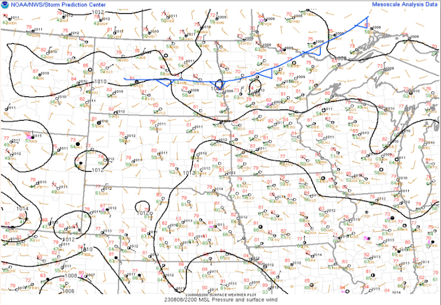
Fig 1. Storm Prediction Center Mesoanalysis valid 2200 UTC.
Good afternoon central Minnesota. Not much has changed with how the weather looks for the forecast period with regards to temperature but there have been some adjustments to our precipitation chances through late week.
Currently, there is a cold front extending down from Canada across northern Minnesota and through central North Dakota based on pressure, wind and temperature trends over the last few hours.
We can also see the cold front on satellite and radar, with showers and thunderstorms developing out ahead of it across northern Minnesota into central North Dakota. These showers and thunderstorms will likely begin weakening after we loss daytime heating and instability and most CAM's indicate the line should dissipate by the time it reaches I-94 or just a little south of there. While precipitation chances will be generally low going into the evening, these storms are a little close for comfort for me personally to leave out a mention at some scattered shower and thunderstorm activity, especially for our northern and central counties such as Douglas, Pope, Todd, Morrison, Crow Wing, Stearns, Benton, Sherburne, and Mille Lacs counties. Once you get south of these countries I think most of the precipitation should be very light if there is any left at all.
Temperature wise, we won't really see the effects of the cold quite yet with lows being around 60F for the entire forecast area with the possibility of some slightly cooler temperatures in the northern counties. Nothing lower than upper 50F's however.
Tomorrow, we will still be under the influence of the cold front it seems with the possibility of some afternoon showers and thunderstorms, with the best chance this time being along and south of I-94. I don't expect any severe weather nor does the SPC, so nothing to worry about other than some spotty rain. Nothing to cancel any afternoon plans over though in my opinion, just keep an eye on radar and the sky as storms can fire rather quickly and seemingly out of nowhere in environments like what we could have tomorrow. Highs will be in the upper 70F's to lower 80F's across the area so nothing too oppressive in terms of heat.
Fig 3. NAM-3km run simulation capturing the cold front potential position and where storms may fire along said cold front. Imagery courtesy of tropicaltidbits.com.
Tomorrow night lows are really going to dip behind the cold front with temperatures in our northern counties getting into the low 50F's and temperatures in the central and southern areas being in the mid to upper 50F's.
Thursday things generally remain unchanged. I am still watching a trough of low pressure advecting eastward toward the west coast of the United States. By Thursday into Thursday Night, the shortwave trough will likely acquire a negative tilt but may be less potent than what models were thinking yesterday. I wouldn't be shocked to see this trend continue given the overall synoptic pattern we are in with a long lasting Hudson Bay/ East Coast trough sticking around de-amplifying the flow closer to our neck of the woods.
Shower and storm chances are still certainly in place for Thursday Night at this point however, but I am not confident enough in this set up yet to go all in as the NWS Twin Cities has with the rain chance %'s. I am keeping my chances at 30%-40% given the question of if this trough will still exist by the time it reaches the Dakota's and if instability and moisture return will be adequate for storm development. Currently I am leaning more toward a less moist environment given the passage of the cold front tomorrow. Also, timing for the storms to track through has shifted to late Thursday Night and early Friday Morning. If this indeed transpires, instability will be lower than earlier in the night, so not only does this lower severe weather potential but it could well lower storm potential as well.
EPS and GEFS show between 0.5-0.75 inches of accumulated precipitation through Friday morning with most coming from Thursday Night, but again, these storms may not even exist and I for sure do not expect widespread rain given A.) the potential lack of instability and moisture and B.) the trend of this summer in general, which has not once featured a widespread rain event for central Minnesota.
Bottom line, if you are hoping for rain, don't get your hopes up for tonight through the weekend, as there seems to be scattered chances at best overall. The best chance though does appear to be Thursday Night, so I will continue to be keeping as eye on that trough to our west and see what it does over the next 24-36 hours and hopefully confidence increases one way or another...hopefully toward a solution that features at least some rain for us folks who REALLY need it.


Comments
Post a Comment