June 6th Central Minnesota Weather Update
Central Minnesota June 6th Weather Update
by Aidan Cera

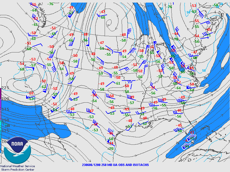
Figure 1. SPC 250 mb chart showing wind with barbs and coloring as well as 250 mb temperature and dewpoint at 12Z 06/06/2023.
The 250 mb wind map summarized the stagnant weather pattern we have been stuck in for quite some time. A stout upper level high pressure is stationed over Manitoba as of 12Z today (Tuesday). We also see troughing off the east coast and over the far western United States. This Omega Block pattern has led to stalled weather across the central United States.
Unfortunately, there is no model indication of this pattern breaking down until sometime next week, so we will stuck in this stagnant weather pattern for the foreseeable future. The good news is that cooler temperatures have made their way into central Minnesota after yesterday's cold frontal passage and another one on the way Friday. This front has also lowered the dew point slightly across central Minnesota with the more significant drops in dew points across northern Minnesota into the more comfortable range. Regardless, a slight temperature and dew point drop is welcomed after the recent bout of weather we have seen.
Fig 2. NCAR/RAL satellite imagery as of 22:02:36 UTC Tuesday.
After some showers moved through central Minnesota this morning bringing some much needed (although a minor amount of) rain, clouds have cleared out and we really don't have any clouds to speak of across most of central MN. This will likely change going into the overnight hours as remnant cloud cover associated with the convection blossoming across western MN and the Dakota's works its way down courtesy of the upper level NW flow around the high. I am not really expecting much in terms of thunderstorm chances overnight tonight. The best chance of anything would be in central Minnesota's far western counties such as Douglas and Pope counties. Lows tonight are expected to range from the lower 50Fs up near Brainerd, MN to upper 50Fs to near 60F down near Hutchinson, MN and out near Alexandria, MN.
As we head into tomorrow, I think will could still have a fair deal of cloud cover hanging around from any overnight convection that takes place across far western and northern Minnesota. A left over shower is possible but I certainly would not bank on seeing any rain across central MN tomorrow with the cold front advancing further west...yes west, that wasn't a typo. Speaking of the cold front, cooler high temperatures are expected again tomorrow thanks to the wrong way moving front, with highs ranging from the mid 70Fs to low 80Fs depending on how much sunshine you see and how far north and east you are.
Tomorrow Night things looks pretty tranquil across central MN with no rain expected and partly cloudy skies. Lows will be dropping to near 50F for central Minnesota's northern counties such as Todd, Crow Wing and Morrison counties and upper 50Fs further south.
Looking ahead to Thursday things look dry once again with partly cloudy skies and highs around the same as on Wednesday. Some models such as the GFS show slightly cooler high temperatures but decided to regard the model as an outlier for now.
Now I know I said Friday looks like our best chance of any precipitation in yesterday's outlook. It looks like I have to retract that statement given the model trends today unfortunately. I know, I had some higher hopes as well but it looks like the drought like conditions will keep a firm hold on our weather.
So what changed?
Figure 3. Atmospheric sounding model for central Minnesota Friday afternoon into the evening hours. Sounding courtesy of tropicaltidbits.com
Looking at soundings, energy in the atmosphere (CAPE) and the thermodynamics don't look all that bad, perhaps there is a bit more dry air than I would like to see but I don't think the issue lies here. It seems the issue is that the frontal boundary that is not expected to track through is just being shown as a weak boundary at this point and barely even a front. Given this, there likely won't be a whole lot of forcing to give air parcels much a boost so any convection that does take place is going to be dependent on daytime heating. So, storm chances on Friday appear to now be more of the spotty type which is such a surprise given our recent weather trend....not.
The silver lining in this though is that dew points are expected to drop quite a bit back into a more comfortable range for all of Minnesota going into the weekend so we won't be adding all of the humidity to the heat as we have been the last week or so. Dry conditions will also follow this weekend, so a beautiful weekend seems to lie ahead for central MN.
That about sums up the forecast for the remainder of this week. Should be back tomorrow with a forecast update schedule permitting. A general 48-hr forecast is posted below. Have a fantastic evening everyone!


Comments
Post a Comment