June 11th Central MN Weather Update
June 11th Central Minnesota Weather Update
by Aidan Cera
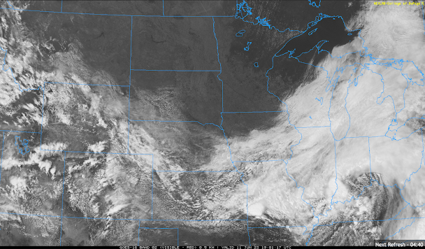
Figure 1. Satellite view of the Upper Midwest and Great Lake region valid as of around 1909Z 06/11/23.
Happy Sunday everyone! I apologize for not posting any weather updates over the last few days. I have been pretty sick and have not had the energy to even get out of bed much so making forecasts would have been a stretch. Thankfully the sinus infection side of whatever I have seems to be going away so I'm more active today!
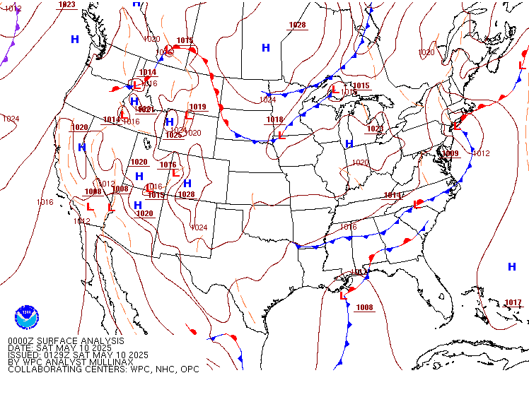
The weather on the other hand? Nope. Dead quiet around not just central Minnesota but ALL of Minnesota. Some fair weather cumulus clouds are present near the Canadian border but these really aren't bothering anyone. Winds are slightly gusty out of the NE at about 25 mph or so. This quiet, dry and windier weather is courtesy of the cold front that passed through yesterday and the high pressure building in from the north shown below in the WPC surface front chart.

Figure 2. Weather Prediction Center 1500Z Surface Analysis chart.
Skies will remain sunny the rest of today and clear overnight tonight. Lows are expected to be a bit chilly with temperatures between the mid to upper 40Fs to lower 50Fs.
Heading into tomorrow, it is expected that a low pressure system will form to our east over Michigan and push precipitation associated with the low back westward into Wisconsin. No precipitation is expected across Minnesota from the retrograding low but there likely will be enough parcel lift due to proximity to the low for some cumulus type clouds to form, especially during the afternoon. Winds will be out generally out of the northwest at 10 to 15 mph across much of central Minnesota with gusts up to 20 mph, similar to today. Highs are expected to be a decent bit warmer with temperatures in the low 80s across much of the forecast area.
Looking at clear skies tomorrow night with those northwest winds diminishing with lows falling into the mid to upper 50Fs. Things look quiet through most of this week in fact...a large sprawling high pressure coming down from wildfire/drought stricken Canada. As a weather forecaster I honestly have to say this has been the most boring stretch of weather I can ever remember. Yes not having rain interrupt outdoor plans is nice, however, we really need the rain and that rain just does not seem to be anywhere in site.
Short discussion today but there just really isn't much to talk about. Hope everyone has a fantastic rest of their weekend and enjoys their Monday!
General central Minnesota forecast is below.


Comments
Post a Comment