Another Round of Storms Possible For Southeastern Wisconsin Later This Evening
05/24/24 Weather Outlook Southeastern Wisconsin
by Aidan Cera

We have already had a round of showers and thunderstorms make their way through southeastern Wisconsin earlier this morning into the early afternoon. This round has since departed and dissipated for the most part out over Lake Michigan as was expected. We are still seeing a good deal of cloud cover across southeastern Wisconsin however, which has stunted temperature rebound a fair bit after the surge of post storm rain cooled air. We are seeing thunderstorm redevelopment across far southwestern Wisconsin into eastern Iowa that will need to be watched over the next few hours as they track northeast.
Looking at current satellite imagery, there does appear to be increasing sunshine across Racine, Kenosha and Walworth counties, which will likely soon work its way further north within the next hour or so.

The amount of clearing that we see through the remainder of the afternoon before the highly forced band of clouds over eastern Iowa arrives will determine the threat southeastern Wisconsin will have for severe weather heading into the evening. I think that thunderstorms are almost a guarantee given storm formation in southwestern Wisconsin, where the sun has barely shone itself all day. This establishes that it really isn't a question of how well the atmosphere can recharge, which is further evidenced by the lack of appreciable CAPE near the currently severe warned storms out to our west. This leads me to believe that the low level jet and strong shear along the cold front is the main culprit for these storms, and I really do not see why these influencers will change all that much across southern Wisconsin over the next several hours.
Thunderstorms are most likely to arrive an hour or two before sunset and may linger until after sunset depending on how the storms progress the remainder of the afternoon into the evening. There are hints at prefrontal development near Walworth county as and areas south as well, which may be associated with the nose of the previously mentioned low level jet. That being said, storm chances are around at least until after sunset, but the best chance will likely be around sunset give and take 1-2 hrs.
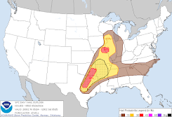
There will be a threat of damaging winds, large hail and even a brief spin up tornado with these storms. The Storm Prediction Center has issued a slight risk of severe weather for southern Wisconsin as a response to these threats. Fortunately, the tornado risk has been lowered across southern Wisconsin but the damaging wind and large hail threat still remains.


Clouds will clear out tonight behind the storms with low temperatures dropping into the upper 40ºF's inland and low 50ºF's lakeside. Saturday looks absolutely beautiful, with very little cloud cover through a majority of the day, plenty of sunshine and warmer temperatures as a result. Highs will likely reach into the mid 70ºF's for our inland areas with highs in the upper 60ºF's near the lake. Clouds increase going into tomorrow night as our next weather system approaches from the southwest.
A negatively tilted shortwave trough is expected to advect out of the Rockies Saturday, and swing across the Upper Mississippi Valley on Sunday, then into the Great Lakes region Sunday afternoon into Sunday Night. Associated divergence aloft will promote plenty of forcing for shower and thunderstorm development as this wave and accompanying low pressure swing through these regions. The main questions will be coverage during the day on Sunday. Most mesoscale models show very little in terms of rain and storms for Sunday as of the most recent trends, with the global models showing appreciable Precipitable Water (PWAT) values advancing northward ahead of the low. In theory, this should result in widespread precipitation across the area Sunday afternoon at least. There is the potential for redevelopment of storms Sunday late evening into the overnight hours as the low itself and accompanying cold front tracks through, but models vary on coverage and intensity of said storms. The primary risk of severe weather is expected to be to our south, across Illinois and Indiana.
Highs will struggle to climb into the mid 60ºF's most likely on Sunday given the cloud cover and at least scattered showers. The lake will likely not affect temperatures all that much given the rain tracking through the area.
Heading into your Memorial Day holiday, shower and storm chances will likely continue with the potential for wrap around precipitation around the low that will be positioned to our northwest. Precipitation is unlikely to be very widespread, but gusty northwest winds and cloud cover will likely make it once again hard for highs to climb above the mid 60ºF's. Tuesday seems to be the same story, with scattered showers and storms possible and highs in the mid 60ºF's across most of the region. Due to the northwest winds, the lake breeze will likely have little effect on lakeside temperatures during this time as well. More mild temperatures look to arrive into the middle of next week, with drier weather and plenty of sunshine past Wednesday.


Comments
Post a Comment